IMAGES TAKEN NEAR TO
Kingsley Avenue, CAMBERLEY, GU15 2NB
Introduction
This page details the photographs taken nearby to Kingsley Avenue, GU15 2NB by members of the Geograph project.
The Geograph project started in 2005 with the aim of publishing, organising and preserving representative images for every square kilometre of Great Britain, Ireland and the Isle of Man.

There are currently over 7.5m images from over14,400 individuals and you can help contribute to the project by visiting https://www.geograph.org.uk
Image Map
Images are licensed for reuse under creativecommons.org/licenses/by-sa/2.0
Notes
- Clicking on the map will re-center to the selected point.
- The higher the marker number, the further away the image location is from the centre of the postcode.
Image Listing (7 Images Found)
Images are licensed for reuse under creativecommons.org/licenses/by-sa/2.0
Image
Details
Distance
2
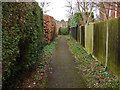
Footpath, Camberley
The narrow footpath that runs along the side of Camberley Cricket Ground.
Image: © Alan Hunt
Taken: 4 Mar 2014
0.17 miles
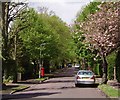
3
Parkway, Camberley
Looking north along this residential road named after its proximity to Watchetts Park.
Image: © Alan Hunt
Taken: 4 Mar 2014
0.19 miles
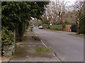
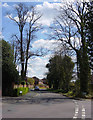
5

Verran Road, Camberley
The junction of Watchetts Drive with Verran Road
Image: © Alan Hunt
Taken: 4 Mar 2014
0.20 miles
6
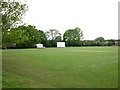
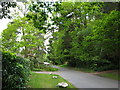
Camberley Cricket Field
The cricket field of Camberley Cricket Club.
Image: © don cload
Taken: 18 May 2010
0.20 miles
7
Verran Road
Photo taken looking down Verran Road from the junction with Watchetts Drive in this quiet residential area of Camberley.
Image: © Euchiasmus
Taken: 15 Apr 2008
0.22 miles