IMAGES TAKEN NEAR TO
Kingsclear Park, CAMBERLEY, GU15 2LS
Introduction
This page details the photographs taken nearby to Kingsclear Park, GU15 2LS by members of the Geograph project.
The Geograph project started in 2005 with the aim of publishing, organising and preserving representative images for every square kilometre of Great Britain, Ireland and the Isle of Man.

There are currently over 7.5m images from over14,400 individuals and you can help contribute to the project by visiting https://www.geograph.org.uk
Image Map
Images are licensed for reuse under creativecommons.org/licenses/by-sa/2.0
Notes
- Clicking on the map will re-center to the selected point.
- The higher the marker number, the further away the image location is from the centre of the postcode.
Image Listing (15 Images Found)
Images are licensed for reuse under creativecommons.org/licenses/by-sa/2.0
Image
Details
Distance
1
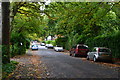
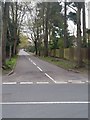
Heatherdale Road
Accurately describable as a leafy suburb.
Image: © David Martin
Taken: 29 Sep 2017
0.10 miles
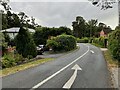
3

Roundabout at the junction of Park Road and Park Street, Camberley
From Park Road, Park Street to the left, Park Road continues ahead.
Image: © Rich Tea
Taken: 21 Apr 2016
0.13 miles
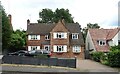
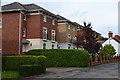
4
Park Street, Camberley
Telephone exchange on the left.
Image: © Rich Tea
Taken: 21 Apr 2016
0.18 miles
5
Saddlewood, Camberley
Seen from Park Road. An unusual street name.
Image: © Rich Tea
Taken: 21 Apr 2016
0.20 miles
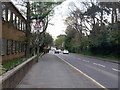
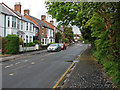
6
Park Avenue, Camberley
From Park Road. A road with tall straight pine trees.
Image: © Rich Tea
Taken: 21 Apr 2016
0.20 miles
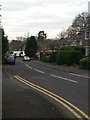
9
Gordon Road, Camberley
Looking northeast towards the junction with Park Street.
Image: © Alan Hunt
Taken: 29 Apr 2014
0.24 miles
10

Gordon Road, Camberley
From the junction with Park Street
Image: © Rich Tea
Taken: 21 Apr 2016
0.24 miles