IMAGES TAKEN NEAR TO
Heathcote Road, CAMBERLEY, GU15 2HU
Introduction
This page details the photographs taken nearby to Heathcote Road, GU15 2HU by members of the Geograph project.
The Geograph project started in 2005 with the aim of publishing, organising and preserving representative images for every square kilometre of Great Britain, Ireland and the Isle of Man.

There are currently over 7.5m images from over14,400 individuals and you can help contribute to the project by visiting https://www.geograph.org.uk
Image Map
Images are licensed for reuse under creativecommons.org/licenses/by-sa/2.0
Notes
- Clicking on the map will re-center to the selected point.
- The higher the marker number, the further away the image location is from the centre of the postcode.
Image Listing (81 Images Found)
Images are licensed for reuse under creativecommons.org/licenses/by-sa/2.0
Image
Details
Distance
1
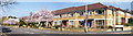
The corner of Upper Park Road & Heathcote Road
This is the corner of Upper Park Road and Heathcote Road showing the cherry blossom trees in full bloom. Camberley station and town centre are at the end of Heathcote Road.
Image: © Len Williams
Taken: 29 Mar 2012
0.03 miles
3
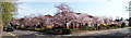
Cherry Blossom
Cherry blossom trees in full bloom on the corner of Upper Gordon Road and Heathcote Road.
Image: © Len Williams
Taken: 29 Mar 2012
0.05 miles
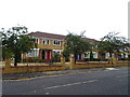
4
Heathcote Road, Camberley
Junction with Middle Gordan Road.
Image: © JThomas
Taken: 25 Jul 2022
0.06 miles
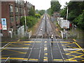
5
Camberley Station from the level crossing
The view from the level crossing to Camberley Station. The line then heads towards Guildford.
Image: © Len Williams
Taken: 29 Mar 2012
0.09 miles
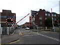
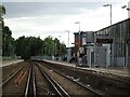
6
Camberley: Heathcote Road level crossing
The London & South Western Railway opened their Ascot to Aldershot route through here and through Camberley station in 1878. This is the view looking towards Bagshot from the station footbridge. The railway was unusually quiet, even for a Sunday, as trains were largely suspended in the area while Network Rail were trying to repair damage reputedly caused by an attempted cable theft in the Woking area on 9 June 2011.
The Ordnance Survey map of the 1870s offers a snapshot of the time with the swathe cut for the route marked as "Unfinished Railway" and a road to a country house called Heathcote running across it.
Image: © Nigel Cox
Taken: 12 Jun 2011
0.09 miles
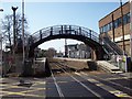
8
Footbridge, Camberley Railway Station
From the level crossing on High Street Camberley.
Image: © JThomas
Taken: 27 Jul 2022
0.09 miles
9
Camberley Railway Station
On the line from Ascot to Ash Vale.
Image: © JThomas
Taken: 25 Jul 2022
0.09 miles
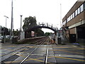
10
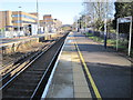
Camberley railway station, Surrey
Opened in 1878 by the London & South Western Railway on the line from Ascot to Ash Vale.
View north east towards Bagshot and Ascot. The station was rebuilt in 1975.
Image: © Nigel Thompson
Taken: 1 Feb 2014
0.09 miles