IMAGES TAKEN NEAR TO
Sandy Lane, CAMBERLEY, GU15 2AG
Introduction
This page details the photographs taken nearby to Sandy Lane, GU15 2AG by members of the Geograph project.
The Geograph project started in 2005 with the aim of publishing, organising and preserving representative images for every square kilometre of Great Britain, Ireland and the Isle of Man.

There are currently over 7.5m images from over14,400 individuals and you can help contribute to the project by visiting https://www.geograph.org.uk
Image Map
Images are licensed for reuse under creativecommons.org/licenses/by-sa/2.0
Notes
- Clicking on the map will re-center to the selected point.
- The higher the marker number, the further away the image location is from the centre of the postcode.
Image Listing (19 Images Found)
Images are licensed for reuse under creativecommons.org/licenses/by-sa/2.0
Image
Details
Distance
1
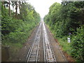
Camberley: Ascot to Guildford railway
The London & South Western Railway opened their Ascot to Aldershot route through here in 1878. This is the view looking towards Image and Camberley station from the Middleton Road bridge. The railway was unusually quiet, even for a Sunday, as trains were largely suspended in the area while Network Rail were trying to repair damage reputedly caused by an attempted cable theft in the Woking area on 9 June 2011.
Image: © Nigel Cox
Taken: 12 Jun 2011
0.08 miles
2
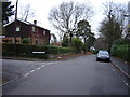
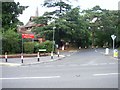
Junction of Crawley Ridge and Branksome Park Rd
A pleasant housing area a few minutes from Camberley centre
Image: © Graham Clutton
Taken: 4 Jan 2006
0.10 miles
3
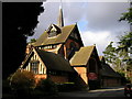
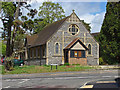
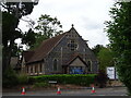
St. Paul's Church, Camberley
Picturesque church at the top of Church Hill!
Image: © don cload
Taken: 9 Mar 2009
0.12 miles
5
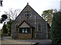
St. Paul's Church Hall, Camberley
The church hall is immediately beside St. Paul's church.
Image: © don cload
Taken: 9 Mar 2009
0.12 miles
6
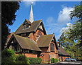
St Paul's Church, Camberley
This fine Arts and Crafts church based on a Scandinavian stave church was designed by W. D. Caroe. The foundation stone was laid in 1902 and the church dedicated in 1907. The extension at the far end appears to have been added at a later date.
Image: © Alan Hunt
Taken: 9 May 2013
0.13 miles
7
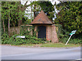
Gate, Tudor Hall
An old gateway to Tudor Hall on the junction of Crawley Ridge and Branksome Park Road
Image: © Alan Hunt
Taken: 9 May 2013
0.13 miles
8
St Paul's church hall, Camberley
The church hall on Church Hill was built in 1895 and served as the original church while the new church was being built just behind this hall in Crawley Ridge.
Image: © Alan Hunt
Taken: 9 May 2013
0.14 miles
10
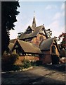
Junction of Crawley Ridge and Church Hill with St Paul's Church
St Paul's Anglican church is located at the top of Church Hill and lies in a commanding position over this grid square, and east Camberley. The original church (now a hall) was built in 1890's and the current church building erected in the early 20th century. This present church building was designed by a Danish architect in Scandinavian style.
Image: © Roger
Taken: Unknown
0.15 miles