IMAGES TAKEN NEAR TO
Longlands Way, CAMBERLEY, GU15 1RH
Introduction
This page details the photographs taken nearby to Longlands Way, GU15 1RH by members of the Geograph project.
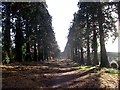
The Geograph project started in 2005 with the aim of publishing, organising and preserving representative images for every square kilometre of Great Britain, Ireland and the Isle of Man.

There are currently over 7.5m images from over14,400 individuals and you can help contribute to the project by visiting https://www.geograph.org.uk
Image Map
Images are licensed for reuse under creativecommons.org/licenses/by-sa/2.0
Notes
- Clicking on the map will re-center to the selected point.
- The higher the marker number, the further away the image location is from the centre of the postcode.
Image Listing (63 Images Found)
Images are licensed for reuse under creativecommons.org/licenses/by-sa/2.0
Image
Details
Distance
1
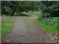
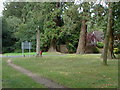
Heatherside, Wellingtonia Avenue.
The footpath that runs the length of the avenue with one of the access points from the houses on either side of the avenue.
Image: © Alan Hunt
Taken: 14 Aug 2011
0.05 miles
2
Copeland Close, Heatherside
Copeland close with Cumberland Road in the foreground.
Image: © Alan Hunt
Taken: 14 Aug 2011
0.08 miles
3
Heatherside Wellintonia Avenue
Some of the trunks of the Wellingtonias from the footpath that runs along the centre of the avenue. Planted in 1865 on behalf of Augustus Mongredien who owned Heatherside House, nearly all of the original 218 trees survive.
Image: © Alan Hunt
Taken: 14 Aug 2011
0.08 miles
4
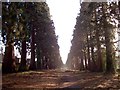
Longlands Way
Longlands Way, sometimes known as Wellingtonia Way, is the old access road to Brookwood House from the Chobham Road. In recent years this has become very overgrown, refer to picture Image which was taken in 2008. Much of the undergrowth has been cleared by the council bringing the avenue back to something like its original state. For another view refer to picture Image
Image: © Len Williams
Taken: 11 Dec 2016
0.09 miles
5
Longlands Way, Camberley
This view of Longlands Way shows the Wellingtonia Pines which form the avenue connecting Brookwood House to the Upper Chobham Road. The undergrowth, which had been strangling the path, has been cleared by the council. Refer to picture Image for another view of the avenue.
Image: © Len Williams
Taken: 11 Dec 2016
0.10 miles
6
Heatherside, Wellingtonia Avenue
The junction between the Wellingtonia Avenue and Cumberland Road.
Image: © Alan Hunt
Taken: 14 Aug 2011
0.11 miles
7
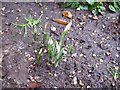
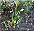
Snowdrops 16th Jan 2017
This bunch of snowdrops has been monitored since 2012 to record the variations of the first day of blooming. This year the blooms appeared on the 16th January. To see the equivalent date in 2016 refer to picture Image
Image: © Len Williams
Taken: 16 Jan 2017
0.11 miles
8
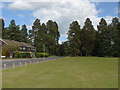
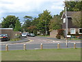
Heatherside recreation ground.
A view along Cumberland Road towards the famous Wellingtonia Avenue.
Image: © Alan Hunt
Taken: 14 Aug 2011
0.11 miles
9
Snowdrops
I have been monitoring this bunch of snowdrops for several years identifying the first day that they bloom. This year was the 8th January. For 2018 refer to picture Image
Image: © Len Williams
Taken: 8 Jan 2019
0.11 miles
10
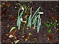
Snowdrops 3rd Jan 2016
I have been monitoring the same bunch of snowdrops in my garden since 2012 noting the date an which they produce their first blooms. This year the first hint of white appeared on the 31st Dec 2015 and a single bloom on the 2nd Jan 2016. On the 3rd the rest of the bunch had caught up. Refer to picture Image for a view of the 2015 bloom and the links to the preceding years.
Image: © Len Williams
Taken: 3 Jan 2016
0.11 miles