IMAGES TAKEN NEAR TO
Kendal Grove, CAMBERLEY, GU15 1QY
Introduction
This page details the photographs taken nearby to Kendal Grove, GU15 1QY by members of the Geograph project.
The Geograph project started in 2005 with the aim of publishing, organising and preserving representative images for every square kilometre of Great Britain, Ireland and the Isle of Man.

There are currently over 7.5m images from over14,400 individuals and you can help contribute to the project by visiting https://www.geograph.org.uk
Image Map
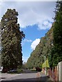
Images are licensed for reuse under creativecommons.org/licenses/by-sa/2.0
Notes
- Clicking on the map will re-center to the selected point.
- The higher the marker number, the further away the image location is from the centre of the postcode.
Image Listing (56 Images Found)
Images are licensed for reuse under creativecommons.org/licenses/by-sa/2.0
Image
Details
Distance
1
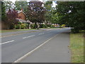
Cumberland Road
A view along Cumberland Road towards the junction with the Maultway.
Image: © Alan Hunt
Taken: 14 Aug 2011
0.06 miles
2
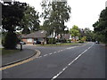
Cumberland Road, Camberley
There is no obvious boundary between Camberley and Frimley but someone is bound to know it.
Image: © David Howard
Taken: 27 Jul 2015
0.07 miles
3
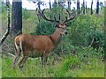
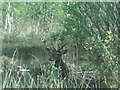
Camberley Deer
Taken on a mobile phone this stag is displaying a full set of antlers, although still covered in velvet.
Image: © Len Williams
Taken: 30 Jul 2013
0.07 miles
4
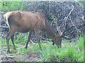
Camberley Stag
One of four stags close to the security fence around the Chobham Range. This one has been radio tagged.
Image: © Len Williams
Taken: 30 Jul 2013
0.08 miles
5
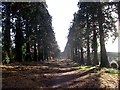
Longlands Way, Camberley
This view of Longlands Way shows the Wellingtonia Pines which form the avenue connecting Brookwood House to the Upper Chobham Road. The undergrowth, which had been strangling the path, has been cleared by the council. Refer to picture Image for another view of the avenue.
Image: © Len Williams
Taken: 11 Dec 2016
0.08 miles
6
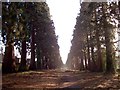
Longlands Way
Longlands Way, sometimes known as Wellingtonia Way, is the old access road to Brookwood House from the Chobham Road. In recent years this has become very overgrown, refer to picture Image which was taken in 2008. Much of the undergrowth has been cleared by the council bringing the avenue back to something like its original state. For another view refer to picture Image
Image: © Len Williams
Taken: 11 Dec 2016
0.09 miles
7
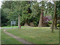
Heatherside, Wellingtonia Avenue
The junction between the Wellingtonia Avenue and Cumberland Road.
Image: © Alan Hunt
Taken: 14 Aug 2011
0.09 miles
8
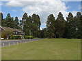
Heatherside recreation ground.
A view along Cumberland Road towards the famous Wellingtonia Avenue.
Image: © Alan Hunt
Taken: 14 Aug 2011
0.10 miles
9
Wellingtonia Pine, Longlands Way
An avenue of Wellintonia pines stretched from the Upper Chobham Road to Brookwood House, (now the Ridgeway Centre). This photo shows the top of the avenue as seen from where it crosses Redwood Drive. The avenue is called Longlands Way.For a different view of the pine avenue refer to picture Image
Image: © Len Williams
Taken: 30 Mar 2008
0.10 miles
10
Deer with Antlers, Camberley
A second view of the deer which has joined the herd on the heath forming the Bisley Ranges. Taken on a mobile phone. Refer to picture Image for another view.
Image: © Len Williams
Taken: 3 May 2015
0.11 miles