IMAGES TAKEN NEAR TO
Roundway, CAMBERLEY, GU15 1NU
Introduction
This page details the photographs taken nearby to Roundway, GU15 1NU by members of the Geograph project.
The Geograph project started in 2005 with the aim of publishing, organising and preserving representative images for every square kilometre of Great Britain, Ireland and the Isle of Man.

There are currently over 7.5m images from over14,400 individuals and you can help contribute to the project by visiting https://www.geograph.org.uk
Image Map
Images are licensed for reuse under creativecommons.org/licenses/by-sa/2.0
Notes
- Clicking on the map will re-center to the selected point.
- The higher the marker number, the further away the image location is from the centre of the postcode.
Image Listing (7 Images Found)
Images are licensed for reuse under creativecommons.org/licenses/by-sa/2.0
Image
Details
Distance
1
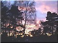
Winter Sunset over Copped Hall, Camberley
A winter sunset from Green Hill Close
Image: © Andrew Pepper
Taken: 5 Feb 1999
0.08 miles
2
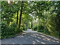
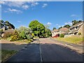
Navigating northwards up the Basher (27)
Looking from Roundway Close into Roundway
Image: © Basher Eyre
Taken: 5 Jun 2023
0.09 miles
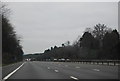
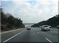
3
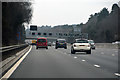
Surrey Heath : M3 Motorway
The M3 Motorway between Junction 3 (Bagshot Interchange) and Junction 4 (Frimley Interchange).
Image: © Lewis Clarke
Taken: 25 Mar 2018
0.12 miles
4
Navigating northwards up the Basher (28)
Lamppost in Roundway
Image: © Basher Eyre
Taken: 5 Jun 2023
0.18 miles
5
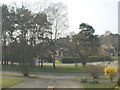
Copped Hall Estate, Camberley
Looking across the green 'island' between Green Hill Close and Green Hill Road.
Image: © Andrew Pepper
Taken: 27 Mar 2003
0.18 miles