IMAGES TAKEN NEAR TO
Seymour Drive, CAMBERLEY, GU15 1LE
Introduction
This page details the photographs taken nearby to Seymour Drive, GU15 1LE by members of the Geograph project.
The Geograph project started in 2005 with the aim of publishing, organising and preserving representative images for every square kilometre of Great Britain, Ireland and the Isle of Man.

There are currently over 7.5m images from over14,400 individuals and you can help contribute to the project by visiting https://www.geograph.org.uk
Image Map
Images are licensed for reuse under creativecommons.org/licenses/by-sa/2.0
Notes
- Clicking on the map will re-center to the selected point.
- The higher the marker number, the further away the image location is from the centre of the postcode.
Image Listing (4 Images Found)
Images are licensed for reuse under creativecommons.org/licenses/by-sa/2.0
Image
Details
Distance
1
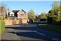
Seymour Drive, Camberley
A modern development on near the eastern edge of the town.
Image: © Andrew Smith
Taken: 18 Apr 2021
0.04 miles
2
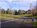
Seymour Drive, Camberley
A new housing estate built in the 1990s on the site of the WRAC college. Seymour drive was the access road to the college.
Image: © Alan Hunt
Taken: 17 Feb 2013
0.16 miles
3
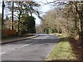
The Maultway
The Maultway from the entrance to the Black Hill car park. This link road runs from Deepcut to the Jolly Farmer roundabout on the A30.
Image: © Alan Hunt
Taken: 17 Feb 2013
0.24 miles
4
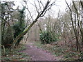
Footpath in woodland
This path runs parallel to The Maultway road.
Image: © don cload
Taken: 23 Feb 2010
0.25 miles