IMAGES TAKEN NEAR TO
Upper Chobham Road, CAMBERLEY, GU15 1HA
Introduction
This page details the photographs taken nearby to Upper Chobham Road, GU15 1HA by members of the Geograph project.
The Geograph project started in 2005 with the aim of publishing, organising and preserving representative images for every square kilometre of Great Britain, Ireland and the Isle of Man.

There are currently over 7.5m images from over14,400 individuals and you can help contribute to the project by visiting https://www.geograph.org.uk
Image Map
Images are licensed for reuse under creativecommons.org/licenses/by-sa/2.0
Notes
- Clicking on the map will re-center to the selected point.
- The higher the marker number, the further away the image location is from the centre of the postcode.
Image Listing (15 Images Found)
Images are licensed for reuse under creativecommons.org/licenses/by-sa/2.0
Image
Details
Distance
1
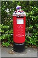
Yarn bombed Elizabeth II postbox on Amber Hill, Camberley
Postbox No. GU15 132.
Image: © JThomas
Taken: 25 Jul 2022
0.05 miles
2
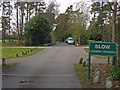
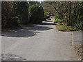
Springfield Road
The golf course crossing point on this unadopted road.
Image: © Alan Hunt
Taken: 19 Apr 2013
0.06 miles
3
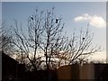
7 Pigeons, 1 Tree
Not a partridge in a pear tree, but 7 pigeons feeding from the gum present on the buds on this tree.
Image: © Len Williams
Taken: 24 Mar 2008
0.06 miles
4
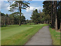
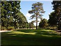
Camberley Heath golf course
A view of one of the greens from Springfield road.
Image: © Alan Hunt
Taken: 19 Apr 2013
0.10 miles
5
Camberley Heath Golf Club
Taken from Springfield Road.
Image: © James Emmans
Taken: 9 Jul 2017
0.10 miles
7
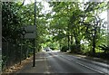
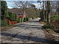
Springfield Road
An unadopted residential road off the Upper Chobham Road in Camberley.
Image: © Alan Hunt
Taken: 19 Apr 2013
0.14 miles
9
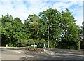
Roundabout on Upper Chobham Road (B311), Heatherside
Image: © JThomas
Taken: 25 Jul 2022
0.15 miles
10
Goldney Road
The section of Goldney Road approaching the Upper Chobham Road. The final section running up to the junction is little more than a footpath.
Image: © Alan Hunt
Taken: 19 Apr 2013
0.16 miles