IMAGES TAKEN NEAR TO
York Road, GUILDFORD, GU1 4EA
Introduction
This page details the photographs taken nearby to York Road, GU1 4EA by members of the Geograph project.
The Geograph project started in 2005 with the aim of publishing, organising and preserving representative images for every square kilometre of Great Britain, Ireland and the Isle of Man.

There are currently over 7.5m images from over14,400 individuals and you can help contribute to the project by visiting https://www.geograph.org.uk
Image Map
Images are licensed for reuse under creativecommons.org/licenses/by-sa/2.0
Notes
- Clicking on the map will re-center to the selected point.
- The higher the marker number, the further away the image location is from the centre of the postcode.
Image Listing (238 Images Found)
Images are licensed for reuse under creativecommons.org/licenses/by-sa/2.0
Image
Details
Distance
2
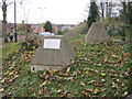
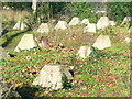
Second World War Tank traps, Guildford
Image: © Nigel Thompson
Taken: 30 Nov 2013
0.01 miles
3
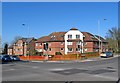
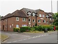
Denehyrst Court, York Road, Guildford
This block of apartments, built in 1989, is on the corner of York Road and London Road. There are 36 flats which offer supported housing for people of 55 or older. It is managed by Peverel Retirement.
Image: © P L Chadwick
Taken: 7 Mar 2011
0.02 miles
4
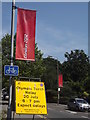
London 2012, Guildford
Banner and road sign on the route of the Olympic Torch Relay - London Road, leading to Stoke Park where there was a large party to welcome the arrival of the Olympic Flame.
www.guildford.gov.uk
Image: © Colin Smith
Taken: 25 Jul 2012
0.02 miles
5
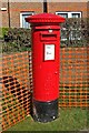
George VI postbox, York Road, Guildford
Located outside Denehyrst Court, not far from the corner of York Road and London Road. The postbox dates from the reign of King George VI (1936-1952).
Postbox number:- GU1 41. Post code:- GU1 4EA. Last collection:- 6.30 pm Monday to Friday; 12 noon Saturday.
Image
Image: © P L Chadwick
Taken: 7 Mar 2011
0.02 miles
6
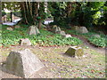
"Dragon's Teeth"
These former WW2 tank obstructions are by the road bridge above Guildford's London Road station. Guildford is a gap town, sited where the Wey flows through the North Downs and was to be a defensive point in the event of a German invasion in 1940. London Road is visible through the trees.
Image: © Colin Smith
Taken: 13 Sep 2006
0.02 miles
7
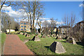
Anti Tank Blocks near the Station
At the end of the car park at London Road Station a short path goes up to London Road.
The concrete blocks date from WW2.
Image: © Des Blenkinsopp
Taken: 14 Mar 2023
0.03 miles
8
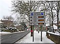
Car parking sign in London Road (A3100)
A useful sign for motorists, near London Road Guildford Railway Station. The road on the left is Clandon Road.
Image: © L S Wilson
Taken: 3 Dec 2010
0.03 miles
9
Dragon's Teeth
WW2 anti-tank defences (1942) beside Guildford's London Road railway station.
www.guildford.gov.uk
Image: © Colin Smith
Taken: 9 Dec 2011
0.03 miles
10
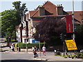
London Road
Quiet road intersection in central Guildford - when the traffic lights are at red. Note the Olympic banner and road sign.
Image: © Colin Smith
Taken: 25 Jul 2012
0.03 miles