IMAGES TAKEN NEAR TO
Herbs End, FARNBOROUGH, GU14 9YD
Introduction
This page details the photographs taken nearby to Herbs End, GU14 9YD by members of the Geograph project.
The Geograph project started in 2005 with the aim of publishing, organising and preserving representative images for every square kilometre of Great Britain, Ireland and the Isle of Man.

There are currently over 7.5m images from over14,400 individuals and you can help contribute to the project by visiting https://www.geograph.org.uk
Image Map (Loading...)


Getting Data...Please wait
Leaflet Map data © OpenStreetMap
Images are licensed for reuse under creativecommons.org/licenses/by-sa/2.0
Notes
- Clicking on the map will re-center to the selected point.
- The higher the marker number, the further away the image location is from the centre of the postcode.
Image Listing (19 Images Found)
Images are licensed for reuse under creativecommons.org/licenses/by-sa/2.0
Image
Details
Distance
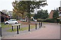
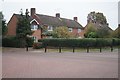
3
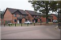
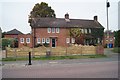
Housing in Ladywood Avenue
Note the mature trees were left during the construction phase of these new builds.
Image: © Fernweh
Taken: 3 Nov 2015
0.23 miles
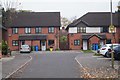
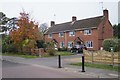
5
Houses in Whetstone Road
Note the CCTV pole, keeping an eye on the shops Image, across the road from here.
Image: © Fernweh
Taken: 3 Nov 2015
0.23 miles
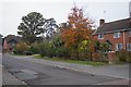
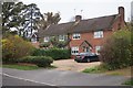
10
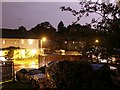
Kenilworth Road
Kenilworth Road at midnight during lightning storm in September 2005.
Image: © Anton Robinson
Taken: 4 Sep 2005
0.24 miles