IMAGES TAKEN NEAR TO
Victoria Gardens, FARNBOROUGH, GU14 9UH
Introduction
This page details the photographs taken nearby to Victoria Gardens, GU14 9UH by members of the Geograph project.
The Geograph project started in 2005 with the aim of publishing, organising and preserving representative images for every square kilometre of Great Britain, Ireland and the Isle of Man.

There are currently over 7.5m images from over14,400 individuals and you can help contribute to the project by visiting https://www.geograph.org.uk
Image Map (Loading...)


Getting Data...Please wait
Leaflet Map data © OpenStreetMap
Images are licensed for reuse under creativecommons.org/licenses/by-sa/2.0
Notes
- Clicking on the map will re-center to the selected point.
- The higher the marker number, the further away the image location is from the centre of the postcode.
Image Listing (71 Images Found)
Images are licensed for reuse under creativecommons.org/licenses/by-sa/2.0
Image
Details
Distance
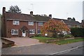
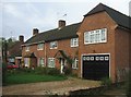
2

Houses in Whetstone Road
Much older than the houses east of her in Chavasse Way.
Image: © Fernweh
Taken: 3 Nov 2015
0.07 miles
6
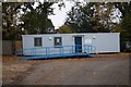
'the whetstone get together'
Community hut at an odd angle, run by Sentinel Housing association.
Image: © Fernweh
Taken: 3 Nov 2015
0.08 miles
8
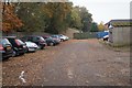
Behind the shops
See Image for a view of the tidier side.
Image: © Fernweh
Taken: 3 Nov 2015
0.10 miles