IMAGES TAKEN NEAR TO
Pennine Way, FARNBOROUGH, GU14 9HW
Introduction
This page details the photographs taken nearby to Pennine Way, GU14 9HW by members of the Geograph project.
The Geograph project started in 2005 with the aim of publishing, organising and preserving representative images for every square kilometre of Great Britain, Ireland and the Isle of Man.

There are currently over 7.5m images from over14,400 individuals and you can help contribute to the project by visiting https://www.geograph.org.uk
Image Map
Images are licensed for reuse under creativecommons.org/licenses/by-sa/2.0
Notes
- Clicking on the map will re-center to the selected point.
- The higher the marker number, the further away the image location is from the centre of the postcode.
Image Listing (80 Images Found)
Images are licensed for reuse under creativecommons.org/licenses/by-sa/2.0
Image
Details
Distance
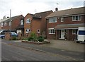
2
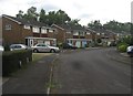
Houses in Cotswold Close
Their gardens back onto the M3.
Image: © Fernweh
Taken: 9 Jun 2015
0.10 miles
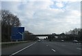
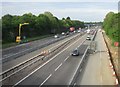
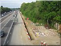
8
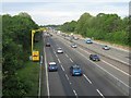
Building a 'Smart' motorway (M3)
View towards Fleet from Fernhill Road bridge.
Image: © Fernweh
Taken: 22 May 2015
0.13 miles
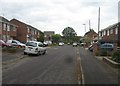
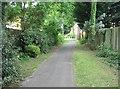
10
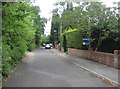
Old route of Fernhill Road
Before the M3 was built at the end of this view.
Image: © Fernweh
Taken: 9 Jun 2015
0.16 miles