IMAGES TAKEN NEAR TO
Nightjar Close, FARNBOROUGH, GU14 9GB
Introduction
This page details the photographs taken nearby to Nightjar Close, GU14 9GB by members of the Geograph project.
The Geograph project started in 2005 with the aim of publishing, organising and preserving representative images for every square kilometre of Great Britain, Ireland and the Isle of Man.

There are currently over 7.5m images from over14,400 individuals and you can help contribute to the project by visiting https://www.geograph.org.uk
Image Map
Images are licensed for reuse under creativecommons.org/licenses/by-sa/2.0
Notes
- Clicking on the map will re-center to the selected point.
- The higher the marker number, the further away the image location is from the centre of the postcode.
Image Listing (18 Images Found)
Images are licensed for reuse under creativecommons.org/licenses/by-sa/2.0
Image
Details
Distance
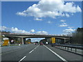
1
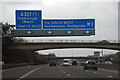
Rushmoor : M3 Motorway
The M3 Motorway between Junction 4 (Frimley Interchange) and Junction 4A (Fleet).
Image: © Lewis Clarke
Taken: 25 Mar 2018
0.08 miles
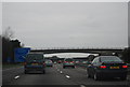
2
Cove : M3 Motorway
The M3 Motorway between Junction 4A (Minley) and Junction 4 (Frimley).
Image: © Lewis Clarke
Taken: 12 Sep 2020
0.08 miles
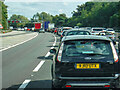
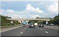
3
M3 westbound
Junction 4a ahead, for the A327.
Image: © Robin Webster
Taken: 16 Dec 2017
0.10 miles
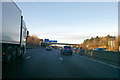
8
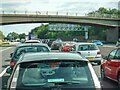
Cove : M3 Motorway
The M3 Motorway between Junction 4A (Minley) and Junction 4 (Frimley).
Image: © Lewis Clarke
Taken: 12 Sep 2020
0.15 miles
9
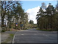
The entrance to Guillemont Park
Guillemont Park is an industrial estate near to Junction 4a of the M3.
Image: © Diane Sambrook
Taken: 7 Apr 2009
0.16 miles
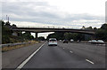
10
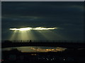
Sunset Over the M3
The bridge in the foreground is Minley Road, crossing over the M3, just before junction 4A.
Image: © Lorraine and Keith Bowdler
Taken: 14 Mar 2010
0.18 miles