IMAGES TAKEN NEAR TO
Mallard Place, FARNBOROUGH, GU14 9FL
Introduction
This page details the photographs taken nearby to Mallard Place, GU14 9FL by members of the Geograph project.
The Geograph project started in 2005 with the aim of publishing, organising and preserving representative images for every square kilometre of Great Britain, Ireland and the Isle of Man.

There are currently over 7.5m images from over14,400 individuals and you can help contribute to the project by visiting https://www.geograph.org.uk
Image Map
Images are licensed for reuse under creativecommons.org/licenses/by-sa/2.0
Notes
- Clicking on the map will re-center to the selected point.
- The higher the marker number, the further away the image location is from the centre of the postcode.
Image Listing (822 Images Found)
Images are licensed for reuse under creativecommons.org/licenses/by-sa/2.0
Image
Details
Distance
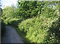
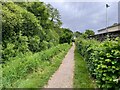
2
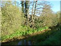
View of Cove Brook
Passing an area of mobile homes.
Image: © Fernweh
Taken: 4 May 2016
0.02 miles
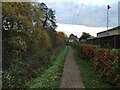
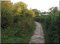
7
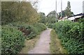
Footpath beside Cove Brook
Mobile home park to the right behind the fence. All just below the M3.
Image: © Fernweh
Taken: 1 Oct 2014
0.03 miles