IMAGES TAKEN NEAR TO
Caswell Close, FARNBOROUGH, GU14 8TE
Introduction
This page details the photographs taken nearby to Caswell Close, GU14 8TE by members of the Geograph project.
The Geograph project started in 2005 with the aim of publishing, organising and preserving representative images for every square kilometre of Great Britain, Ireland and the Isle of Man.

There are currently over 7.5m images from over14,400 individuals and you can help contribute to the project by visiting https://www.geograph.org.uk
Image Map (Loading...)


Getting Data...Please wait
Leaflet Map data © OpenStreetMap
Images are licensed for reuse under creativecommons.org/licenses/by-sa/2.0
Notes
- Clicking on the map will re-center to the selected point.
- The higher the marker number, the further away the image location is from the centre of the postcode.
Image Listing (362 Images Found)
Images are licensed for reuse under creativecommons.org/licenses/by-sa/2.0
Image
Details
Distance
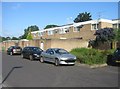
1
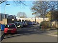
Housing off Carmarthan Close
Typical enclosed area of the housing development.
Image: © Fernweh
Taken: 23 Sep 2016
0.01 miles
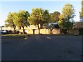
7
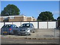
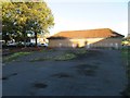
Garages in Caswell Close
Until recently there was another line of identical garages where the cars are now parked. The area has a much more welcoming feel now that they are gone and there is more open space.
Image: © Fernweh
Taken: 3 Jun 2015
0.04 miles
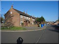
8
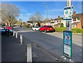
Bus stop on Wren Way
Covid-19 related signage is still in place, although all restrictions had been lifted by the time this photo was taken.
Image: © Fernweh
Taken: 11 Apr 2022
0.05 miles