IMAGES TAKEN NEAR TO
Woburn Avenue, FARNBOROUGH, GU14 7HQ
Introduction
This page details the photographs taken nearby to Woburn Avenue, GU14 7HQ by members of the Geograph project.
The Geograph project started in 2005 with the aim of publishing, organising and preserving representative images for every square kilometre of Great Britain, Ireland and the Isle of Man.

There are currently over 7.5m images from over14,400 individuals and you can help contribute to the project by visiting https://www.geograph.org.uk
Image Map (Loading...)


Getting Data...Please wait
Leaflet Map data © OpenStreetMap
Images are licensed for reuse under creativecommons.org/licenses/by-sa/2.0
Notes
- Clicking on the map will re-center to the selected point.
- The higher the marker number, the further away the image location is from the centre of the postcode.
Image Listing (41 Images Found)
Images are licensed for reuse under creativecommons.org/licenses/by-sa/2.0
Image
Details
Distance
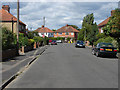
2

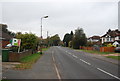
Woburn Avenue, Farnborough
Woburn Avenue with the junction of Stourehead Close on the right.
Image: © Alan Hunt
Taken: 12 Aug 2013
0.07 miles
3
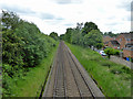
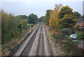
Guildford to Wokingham line
Looking south from Coleford Bridge Road.
Image: © Robin Webster
Taken: 21 May 2017
0.08 miles
4
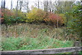
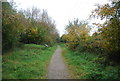
Marshy pond by the Blackwater Valley Path
Image: © N Chadwick
Taken: 30 Oct 2011
0.08 miles
7
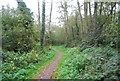
Ashley Road, Farnborough
Looking north along Ashley Road towards the junction with Woburn Avenue.
Image: © Alan Hunt
Taken: 12 Aug 2013
0.12 miles