IMAGES TAKEN NEAR TO
Lynchford Lane, FARNBOROUGH, GU14 6JB
Introduction
This page details the photographs taken nearby to Lynchford Lane, GU14 6JB by members of the Geograph project.
The Geograph project started in 2005 with the aim of publishing, organising and preserving representative images for every square kilometre of Great Britain, Ireland and the Isle of Man.

There are currently over 7.5m images from over14,400 individuals and you can help contribute to the project by visiting https://www.geograph.org.uk
Image Map (Loading...)


Getting Data...Please wait
Leaflet Map data © OpenStreetMap
Images are licensed for reuse under creativecommons.org/licenses/by-sa/2.0
Notes
- Clicking on the map will re-center to the selected point.
- The higher the marker number, the further away the image location is from the centre of the postcode.
Image Listing (73 Images Found)
Images are licensed for reuse under creativecommons.org/licenses/by-sa/2.0
Image
Details
Distance
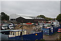
2
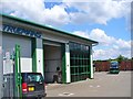
North Camp - Truemans Bus Depot
Lynchford Lane, North Camp - commercial land use by the Blackwater Valley Path.
Image: © Colin Smith
Taken: 23 May 2016
0.04 miles
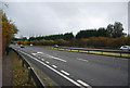
8
Construction site in the Blackwater Valley
Image: © N Chadwick
Taken: 30 Oct 2011
0.08 miles
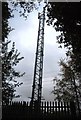
9
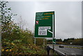
Road sign above the Blackwater Valley Path
Image: © N Chadwick
Taken: 30 Oct 2011
0.08 miles
10
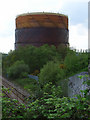
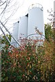
Gas-holder, Farnborough
From the bridge carrying the A331 and the Blackwater Valley Way over the railway near North Camp station.
Image: © Andrew Smith
Taken: 7 May 2006
0.08 miles