IMAGES TAKEN NEAR TO
Lynchford Road, FARNBOROUGH, GU14 6HF
Introduction
This page details the photographs taken nearby to Lynchford Road, GU14 6HF by members of the Geograph project.
The Geograph project started in 2005 with the aim of publishing, organising and preserving representative images for every square kilometre of Great Britain, Ireland and the Isle of Man.

There are currently over 7.5m images from over14,400 individuals and you can help contribute to the project by visiting https://www.geograph.org.uk
Image Map (Loading...)


Getting Data...Please wait
Leaflet Map data © OpenStreetMap
Images are licensed for reuse under creativecommons.org/licenses/by-sa/2.0
Notes
- Clicking on the map will re-center to the selected point.
- The higher the marker number, the further away the image location is from the centre of the postcode.
Image Listing (8 Images Found)
Images are licensed for reuse under creativecommons.org/licenses/by-sa/2.0
Image
Details
Distance
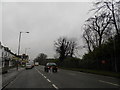
2
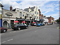
A3011 Lynchford Road, South Farnborough
Heading west, Lille Barracks is behind the fence on the left.
Image: © Robin Webster
Taken: 22 Aug 2020
0.10 miles
5
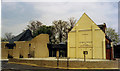
Our Lady Help of Christians, Farnborough
Built in 1898.
Image: © Michael FORD
Taken: Unknown
0.16 miles
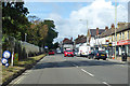
6
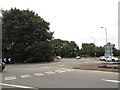
Roundabout on Lynchford Road, North Camp
Lynchford Road has five roundabouts on its short extent.
Image: © David Howard
Taken: 5 Sep 2016
0.19 miles
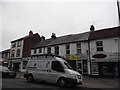
7
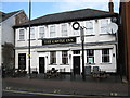
The Castle Inn
Notice the rather elegant clock over the top half of one of the windows.
Image: © don cload
Taken: 16 Feb 2012
0.20 miles
8
The North Camp, Lynchford Road
A sports bar near North Camp Barracks with a 12ft x 12ft screen.
Image: © Peter Holmes
Taken: 28 Jul 2012
0.24 miles