IMAGES TAKEN NEAR TO
Yeovil Road, FARNBOROUGH, GU14 6EX
Introduction
This page details the photographs taken nearby to Yeovil Road, GU14 6EX by members of the Geograph project.
The Geograph project started in 2005 with the aim of publishing, organising and preserving representative images for every square kilometre of Great Britain, Ireland and the Isle of Man.

There are currently over 7.5m images from over14,400 individuals and you can help contribute to the project by visiting https://www.geograph.org.uk
Image Map
Images are licensed for reuse under creativecommons.org/licenses/by-sa/2.0
Notes
- Clicking on the map will re-center to the selected point.
- The higher the marker number, the further away the image location is from the centre of the postcode.
Image Listing (55 Images Found)
Images are licensed for reuse under creativecommons.org/licenses/by-sa/2.0
Image
Details
Distance
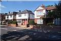
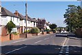
1
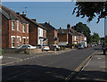
Park Road, North Camp
Looking south along Park Road in North Camp, a suburb of Aldershot. The houses date from the Edwardian era.
Image: © Alan Hunt
Taken: 6 Jul 2013
0.06 miles
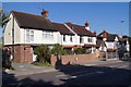
4
The Squirrel - Park Road
See Image for another view.
Image: © Fernweh
Taken: 1 Oct 2015
0.12 miles
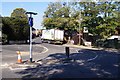
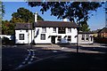
6
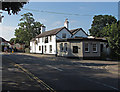
The Squirrel, Park Road
The Squirrel Public House on the junction of Park Road and Reading Road in North Camp.
Image: © Alan Hunt
Taken: 6 Jul 2013
0.12 miles