IMAGES TAKEN NEAR TO
Holly Road, FARNBOROUGH, GU14 0EA
Introduction
This page details the photographs taken nearby to Holly Road, GU14 0EA by members of the Geograph project.
The Geograph project started in 2005 with the aim of publishing, organising and preserving representative images for every square kilometre of Great Britain, Ireland and the Isle of Man.

There are currently over 7.5m images from over14,400 individuals and you can help contribute to the project by visiting https://www.geograph.org.uk
Image Map (Loading...)


Getting Data...Please wait
Leaflet Map data © OpenStreetMap
Images are licensed for reuse under creativecommons.org/licenses/by-sa/2.0
Notes
- Clicking on the map will re-center to the selected point.
- The higher the marker number, the further away the image location is from the centre of the postcode.
Image Listing (237 Images Found)
Images are licensed for reuse under creativecommons.org/licenses/by-sa/2.0
Image
Details
Distance
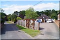
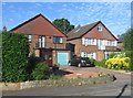
4
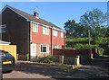
House on Holly Road
The small road leads to a footpath under the railway. An important shortcut for local pedestrians.
Image: © Fernweh
Taken: 7 Apr 2017
0.03 miles
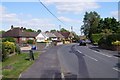
5
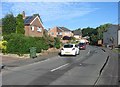
Houses off Holly Road
No passing road traffic but non-stop trains (embankment in background) on the main line to London.
Image: © Fernweh
Taken: 4 Jun 2015
0.03 miles
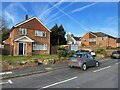
6
Old route under the railway
See Image for an earlier view and background information.
Image: © Fernweh
Taken: 26 May 2015
0.03 miles
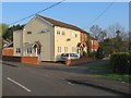
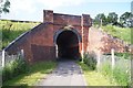
10
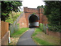
Cove: Frog Lane railway bridge
The 1874 Ordnance Survey 6" to the mile map shows this bridge at the end of Frog Lane (now Holly Road). It is almost certainly therefore part of the original fabric of the railway, dating from no later than 1838. Its original function, pre-dating by a long margin all the housing in the area, would probably have been to provide access to either side of the railway to a farmer whose land had been split by the construction of the embankment. Today it provides a pedestrian route under the railway between Holly Road and West Heath Road.
Image: © Nigel Cox
Taken: 3 Jul 2009
0.04 miles