IMAGES TAKEN NEAR TO
Semaphore Road, GUILDFORD, GU1 3PS
Introduction
This page details the photographs taken nearby to Semaphore Road, GU1 3PS by members of the Geograph project.
The Geograph project started in 2005 with the aim of publishing, organising and preserving representative images for every square kilometre of Great Britain, Ireland and the Isle of Man.

There are currently over 7.5m images from over14,400 individuals and you can help contribute to the project by visiting https://www.geograph.org.uk
Image Map
Images are licensed for reuse under creativecommons.org/licenses/by-sa/2.0
Notes
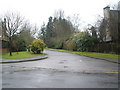
- Clicking on the map will re-center to the selected point.
- The higher the marker number, the further away the image location is from the centre of the postcode.
Image Listing (273 Images Found)
Images are licensed for reuse under creativecommons.org/licenses/by-sa/2.0
Image
Details
Distance
1
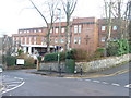
Mount Alvernia Hospital
Private hospital on Harvey Road in the centre of Guildford.
www.guildford.gov.uk
Image: © Colin Smith
Taken: 22 Dec 2011
0.05 miles
2

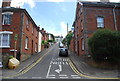
View along Cheselden Road
It took me a while to find this on the map, I've cleverly cut off the 'Che' of Cheselden!
Image: © Nick Smith
Taken: 18 Mar 2009
0.08 miles

6
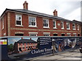
Charlotte Terrace
Red brick terraced housing nearing completion. The block is on Addison Road, Charlotteville in Guildford and is of similar style to the older terrace next door (right, off photograph).
Image: © Colin Smith
Taken: 19 Jul 2012
0.11 miles
8
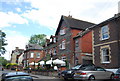
The Albany, Sydenham Rd
A fine flint build pub, on the edge of the town centre.
Image: © N Chadwick
Taken: 3 Jul 2010
0.12 miles
9
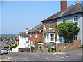
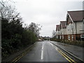
Brodie Road
Steep, residential road of Victorian houses at the bottom of Pewley Down in central Guildford.
Image: © Colin Smith
Taken: 30 Apr 2011
0.12 miles
10
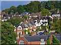
Guildford - Gap Town
Brodie Road, houses built on the eastern slopes of the Wey Gap.
Image: © Colin Smith
Taken: 12 Sep 2015
0.12 miles