IMAGES TAKEN NEAR TO
St. Lukes Square, GUILDFORD, GU1 3JP
Introduction
This page details the photographs taken nearby to St. Lukes Square, GU1 3JP by members of the Geograph project.
The Geograph project started in 2005 with the aim of publishing, organising and preserving representative images for every square kilometre of Great Britain, Ireland and the Isle of Man.

There are currently over 7.5m images from over14,400 individuals and you can help contribute to the project by visiting https://www.geograph.org.uk
Image Map
Images are licensed for reuse under creativecommons.org/licenses/by-sa/2.0
Notes
- Clicking on the map will re-center to the selected point.
- The higher the marker number, the further away the image location is from the centre of the postcode.
Image Listing (66 Images Found)
Images are licensed for reuse under creativecommons.org/licenses/by-sa/2.0
Image
Details
Distance
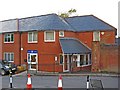
1

St. Lukes Square
A development of apartments, located off Warren Road. This was part of the site of the former St. Lukes Hospital.
Image: © P L Chadwick
Taken: 4 Oct 2010
0.02 miles
2
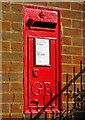
George V wall mounted post box, corner of Warren Road & St. Luke's Square
The post box dates from the reign of George V (1910-1936). It was made by W T Allen & Co., London. There is a possibly worrying crack appearing in the brickwork to the left of the box.
Image: © L S Wilson
Taken: 24 Aug 2009
0.02 miles
3
St. Lukes Surgery, Warren Road
This G.P. practice is located just off Warren Road. Its origins date back as far as 1764, when Dr. William Newland came to Guildford. The practice has been at the present address since 1996. It is on part of the site of the former St. Lukes Hospital. In 2006 the building was extended, and this included an on-site pharmacy. This is operated by Boots the Chemist, but is quite independent of the G.P. practice, and is open to patients of other practices.
Image: © P L Chadwick
Taken: 4 Oct 2010
0.02 miles
4
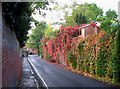
Autumnal colours in Warren Road, looking northwest
The road is leading towards the town centre.
Image
Image: © P L Chadwick
Taken: 4 Oct 2010
0.03 miles
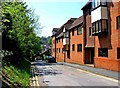
5

Autumnal colours in Warren Road, looking southeast
This part of Warren Road, near the town centre, has high brick walls on both sides.
Image
Image: © P L Chadwick
Taken: 4 Oct 2010
0.03 miles
6
Cooper Road and Alexandra Lodge, Guildford
This end of Cooper Road starts at a junction with Warren Road. It is dominated by Alexandra Lodge, an apartment complex built in about 2004.
Image: © P L Chadwick
Taken: 22 May 2012
0.05 miles
7

'The Spike', Guildford
The remains of what was once Guildford Union Workhouse. Now a museum and community Centre.
Image: © Roger Cornfoot
Taken: 30 Nov 2019
0.08 miles
8
Forresters
This closed Victorian pub at the corner of Cline and Cooper Roads in Charlotteville, Guildford was named The Forester Beerhouse, The Foresters Inn, The Foresters Arms, The Pig and Tater (1976 - as the locals always referred to the pub as this), then back to Forresters (ca 2010).
Image: © Colin Smith
Taken: 30 Nov 2011
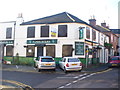
0.08 miles
9

Forresters, 18 Cooper Road
A large back street pub, which offers pools, darts and quiz nights and can host functions. It seems it used to be known as the Forresters Arms.
Update (April 2012) - the pub has been closed for some months. At present it is available to let as a pub, or could possibly be used for other purposes. The agents say the owners may consider selling.
Image
Image: © P L Chadwick
Taken: 10 Mar 2010
0.09 miles
10

Forresters pub sign, 18 Cooper Road
The correct name of the pub is Forresters, but whoever painted the pub sign apparently didn't know this, as it is missing one "R" !
Image
Image: © P L Chadwick
Taken: 10 Mar 2010
0.09 miles