IMAGES TAKEN NEAR TO
High Street, GUILDFORD, GU1 3DL
Introduction
This page details the photographs taken nearby to High Street, GU1 3DL by members of the Geograph project.
The Geograph project started in 2005 with the aim of publishing, organising and preserving representative images for every square kilometre of Great Britain, Ireland and the Isle of Man.

There are currently over 7.5m images from over14,400 individuals and you can help contribute to the project by visiting https://www.geograph.org.uk
Image Map
Images are licensed for reuse under creativecommons.org/licenses/by-sa/2.0
Notes
- Clicking on the map will re-center to the selected point.
- The higher the marker number, the further away the image location is from the centre of the postcode.
Image Listing (2232 Images Found)
Images are licensed for reuse under creativecommons.org/licenses/by-sa/2.0
Image
Details
Distance
2
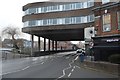
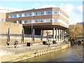
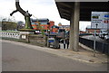
Friary Court over the A281
This is part of the large Friary shopping centre that dominates central Guildford.
Image: © N Chadwick
Taken: 3 Jul 2010
0.00 miles
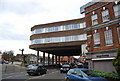
4
Millbrook, Guildford
By the River Wey in central Guildford - architecture to like or dislike.
http://en.wikipedia.org/wiki/Guildford
Image: © Colin Smith
Taken: 26 Apr 2012
0.01 miles
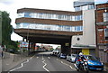
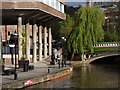
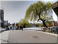
5
Stilted Expression
Guildford's Bridge House is the distinctive development on stilts beside the River Wey.
Image: © Colin Smith
Taken: 12 Mar 2013
0.01 miles
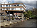
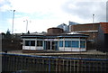
6
Weyside Walk, Millbrook
Town centre walkway along the eastern bank of the River Wey in central Guildford, beside the Town Bridge.
http://en.wikipedia.org/wiki/Guildford
Image: © Colin Smith
Taken: 26 Apr 2012
0.01 miles
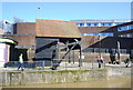
10
Guildford High Street, Pedestrian Bridge over River Wey
The Old Town Bridge is on the site of the "Golden Ford", and it is this ford to which Guildford owes its name. The mediæval bridge was destroyed by a flood in 1900 and it was replaced by an iron bridge two years later. In 1973, the old Town Bridge was closed to traffic and Guildford High Street was pedestrianised for much of the working day (http://www.british-history.ac.uk/vch/surrey/vol3/pp547-560 British History Online).
Image: © David Dixon
Taken: 10 Apr 2015
0.02 miles