
IMAGES TAKEN NEAR TO
Boxgrove Lane, GUILDFORD, GU1 2TB
Introduction
This page details the photographs taken nearby to Boxgrove Lane, GU1 2TB by members of the Geograph project.
The Geograph project started in 2005 with the aim of publishing, organising and preserving representative images for every square kilometre of Great Britain, Ireland and the Isle of Man.

There are currently over 7.5m images from over14,400 individuals and you can help contribute to the project by visiting https://www.geograph.org.uk
Image Map
Images are licensed for reuse under creativecommons.org/licenses/by-sa/2.0
Notes
- Clicking on the map will re-center to the selected point.
- The higher the marker number, the further away the image location is from the centre of the postcode.
Image Listing (4 Images Found)
Images are licensed for reuse under creativecommons.org/licenses/by-sa/2.0
Image
Details
Distance

2

Boxgrove Lane, Guildford.
Boxgrove is a fairly affluent area in east Guildford, a post-war suburb of private housing and popular schools. The number of parked cars and the safety barrier here reflect the "Mums' School Run", ferrying offspring home to save on footwear.
Image: © Colin Smith
Taken: Unknown
0.06 miles
3
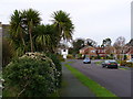
Collingwood Crescent, Boxgrove
Taken at the junction of two streets named after admirals - Collingwood and Frobisher. Large detached houses are common in this desirable area of Guildford. The large trees in the foreground are palms.
Image: © Colin Smith
Taken: 1 Jan 2007
0.21 miles
4

Merrow Woods, Guildford
One of the cul-de-sacs in this collection of roads covered by the name Merrow Woods
Image: © Alan Hunt
Taken: 3 May 2013
0.24 miles