IMAGES TAKEN NEAR TO
Warren Road, GUILDFORD, GU1 2HZ
Introduction
This page details the photographs taken nearby to Warren Road, GU1 2HZ by members of the Geograph project.
The Geograph project started in 2005 with the aim of publishing, organising and preserving representative images for every square kilometre of Great Britain, Ireland and the Isle of Man.

There are currently over 7.5m images from over14,400 individuals and you can help contribute to the project by visiting https://www.geograph.org.uk
Image Map
Images are licensed for reuse under creativecommons.org/licenses/by-sa/2.0
Notes
- Clicking on the map will re-center to the selected point.
- The higher the marker number, the further away the image location is from the centre of the postcode.
Image Listing (58 Images Found)
Images are licensed for reuse under creativecommons.org/licenses/by-sa/2.0
Image
Details
Distance
1
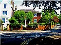
Drayton House School, Drayton House, 35 Austen Road, Guildford
Hidden behind the trees is Drayton House. It is an independent nursery school, which offers part-time and full-time education for children aged from 6 months to 5 years. The school was established in 1943.
Image
Image: © P L Chadwick
Taken: 22 May 2012
0.04 miles
2
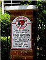
Drayton House School - sign, Drayton House, 35 Austen Road, Guildford
The school was established in 1943.
Image
Image: © P L Chadwick
Taken: 22 May 2012
0.04 miles
3
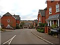
Lancaster Avenue
Viewed from its junction with Warren Road, this avenue is part of a small modern housing development. In the distance can be seen Pewley Down.
Image: © P L Chadwick
Taken: 10 Mar 2010
0.04 miles
4
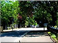
Junction of Warren Road, Upper Edgeborough Road and Lancaster Avenue, Guildford
Three roads meet at this mini-roundabout. Warren Road in the foreground and distance, Upper Edgeborough Road on the left, and Lancasterr Avenue on the right.
Image: © P L Chadwick
Taken: 22 May 2012
0.04 miles
5
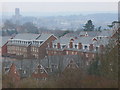
St Luke's
New housing estate on the site of Guildford's former St Luke's Hospital - seen from Pewley Down. In the distance is Guildford Cathedral on Stag Hill.
Image: © Colin Smith
Taken: 24 Feb 2008
0.05 miles
6
Upper Edgeborough Road, Guildford
A mainly residential road, but with a large office development further along the road. The road runs between Warren Road and Epsom Road.
Image: © P L Chadwick
Taken: 22 May 2012
0.06 miles
7
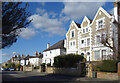
Austen Road, Guildford
A residential street with smart Victorian villas in an assortment of designs.
Image: © Des Blenkinsopp
Taken: 14 Mar 2023
0.07 miles
8
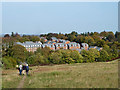
Housing on Lancaster Avenue
A fairly new development, together with similar housing on Sells Close, nearer, but mostly hidden by the trees.
Image: © Robin Webster
Taken: 23 Oct 2011
0.07 miles
9
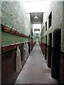
Interior, 'The Spike', Guildford
Cells, provided for itinerants in the Edwardian period.
Image: © Roger Cornfoot
Taken: 30 Nov 2019
0.07 miles
10

Bathing scene at 'The Spike', Guildford
Provided for itinerants in the Edwardian period.
Image: © Roger Cornfoot
Taken: 30 Nov 2019
0.07 miles