IMAGES TAKEN NEAR TO
Ivor Close, GUILDFORD, GU1 2ET
Introduction
This page details the photographs taken nearby to Ivor Close, GU1 2ET by members of the Geograph project.
The Geograph project started in 2005 with the aim of publishing, organising and preserving representative images for every square kilometre of Great Britain, Ireland and the Isle of Man.

There are currently over 7.5m images from over14,400 individuals and you can help contribute to the project by visiting https://www.geograph.org.uk
Image Map
Images are licensed for reuse under creativecommons.org/licenses/by-sa/2.0
Notes
- Clicking on the map will re-center to the selected point.
- The higher the marker number, the further away the image location is from the centre of the postcode.
Image Listing (66 Images Found)
Images are licensed for reuse under creativecommons.org/licenses/by-sa/2.0
Image
Details
Distance
1
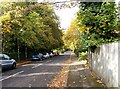
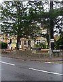
Aldersey Road
Leafy Guildford suburbia, off Epsom Road.
Image: © P L Chadwick
Taken: 23 Oct 2009
0.02 miles
2

Edward VII postbox (detail), St. Omer Road
Showing a close-up of the Royal Cypher of King Edward VII. Image
Image: © P L Chadwick
Taken: 23 Oct 2009
0.05 miles
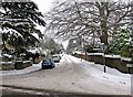
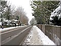
3
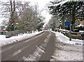
Snow in Epsom Road (A246)
On the left is Maori Road, and on the right is Albury Road.
Image
Image: © L S Wilson
Taken: 3 Dec 2010
0.05 miles
4
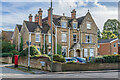
86 Epsom Road
Large late 19th/early 20th Century house on the corner of Epsom Road and St Omer Road, now offices of an engineering consultancy.
Image: © Ian Capper
Taken: 24 Oct 2023
0.05 miles
5
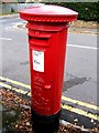
Edward VII postbox, St. Omer Road
On the corner of Epsom Road and St. Omer Road, this is a relatively uncommon Edward VII postbox, as he was only King from 1901 until his death in 1910. It proved difficult to photograph, as it has been positioned very close to the boundary wall of the nearby corner property. Close-up of the Royal Cypher of King Edward VII:- Image
Image: © P L Chadwick
Taken: 23 Oct 2009
0.05 miles
6
The Mantra and The Albury, 78 Epsom Road, Guildford
Located on the corner of Epsom Road (the A246) and Albury Road, this building has recently become The Mantra, an Indian Restaurant, with part of it being The Albury, a hotel. Previously the building housed Quinns Hotel, an establishment popular with Social Security funded guests, and also sometimes used by the Police for decanting homeless people. Those tourists who had the misfortune to stumble across it, soon regretted their mistake, as sites like Tripadvisor will confirm. Hopefully all this has now changed for the better.
Image: © P L Chadwick
Taken: 4 Apr 2012
0.06 miles
7
St Omer Road
St Omer Road dating from the 1920s from its junction with the Epsom Road.
Image: © Alan Hunt
Taken: 20 Apr 2013
0.06 miles
8
Snow in Albury Road, looking from Epsom Road
Several inches of snow had fallen in Guildford, prior to this photograph being taken.
Image: © L S Wilson
Taken: 3 Dec 2010
0.08 miles
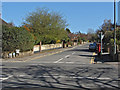
9
Bus stops on Epsom Road
The A246 main road to Guildford centre.
Image: © James Emmans
Taken: 27 Jun 2022
0.08 miles
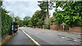
10
Epsom Road (A246) looking towards Guildford town centre
Heavy snow had fallen during the previous night.
Image
Image: © L S Wilson
Taken: 3 Dec 2010
0.09 miles