IMAGES TAKEN NEAR TO
Tyrells Place, GUILDFORD, GU1 2AQ
Introduction
This page details the photographs taken nearby to Tyrells Place, GU1 2AQ by members of the Geograph project.
The Geograph project started in 2005 with the aim of publishing, organising and preserving representative images for every square kilometre of Great Britain, Ireland and the Isle of Man.

There are currently over 7.5m images from over14,400 individuals and you can help contribute to the project by visiting https://www.geograph.org.uk
Image Map
Images are licensed for reuse under creativecommons.org/licenses/by-sa/2.0
Notes
- Clicking on the map will re-center to the selected point.
- The higher the marker number, the further away the image location is from the centre of the postcode.
Image Listing (60 Images Found)
Images are licensed for reuse under creativecommons.org/licenses/by-sa/2.0
Image
Details
Distance
1
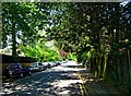
Upper Edgeborough Road, Guildford
A mainly residential road, but with a large office development further along the road. The road runs between Warren Road and Epsom Road.
Image: © P L Chadwick
Taken: 22 May 2012
0.03 miles
2
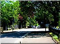
Junction of Warren Road, Upper Edgeborough Road and Lancaster Avenue, Guildford
Three roads meet at this mini-roundabout. Warren Road in the foreground and distance, Upper Edgeborough Road on the left, and Lancasterr Avenue on the right.
Image: © P L Chadwick
Taken: 22 May 2012
0.04 miles
3
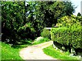
The start of Cross Lanes, Guildford
The narrow path ahead, just off Warren Road, is the start of Cross Lanes. This section goes down to Epsom Road (the A246). The broad track gives access to a private house.
Image: © P L Chadwick
Taken: 22 May 2012
0.05 miles
4
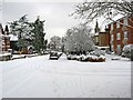
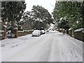
A snow-covered Albury Road
A typical scene in Guildford's minor roads and streets, following further heavy snow a few days before Christmas 2010. The road coming in from the right is Ferndown Close.
Image: © L S Wilson
Taken: 18 Dec 2010
0.06 miles
5
A snow covered Albury Road
In early December 2010, Guildford had some very heavy snowfalls.
Image: © L S Wilson
Taken: 3 Dec 2010
0.06 miles
6
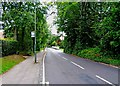
Albury Road
This is the top end of Albury Road (near the junction with Warren Road). At this end there are mainly blocks of privately owned flats. Further down the road, as well as more flats, there is also an hotel or two. These are definitely not focussed on the tourist trade.
Image: © P L Chadwick
Taken: 15 Aug 2009
0.07 miles
7
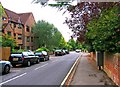
Warren Road, looking west
Looking west from its junction with Albury Road. Warren Road is a long road, most of which is on the southern fringe of Guildford. Behind the vegetation are some very nice houses.
Image: © P L Chadwick
Taken: 15 Aug 2009
0.07 miles
8
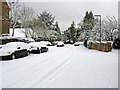
A snow-covered Albury Road
Guildford experienced further very heavy snow a few days before Christmas 2010. Here in Albury Road, which climbs steeply to its junction with Warren Road, the road became very difficult to negotiate. So as a result, quite a few cars were left at the sides of the road.
Image: © L S Wilson
Taken: 18 Dec 2010
0.08 miles
9
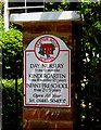
Drayton House School - sign, Drayton House, 35 Austen Road, Guildford
The school was established in 1943.
Image
Image: © P L Chadwick
Taken: 22 May 2012
0.09 miles
10
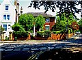
Drayton House School, Drayton House, 35 Austen Road, Guildford
Hidden behind the trees is Drayton House. It is an independent nursery school, which offers part-time and full-time education for children aged from 6 months to 5 years. The school was established in 1943.
Image
Image: © P L Chadwick
Taken: 22 May 2012
0.09 miles