IMAGES TAKEN NEAR TO
Compass Rose Road, GU12 6TY
Introduction
This page details the photographs taken nearby to Compass Rose Road, GU12 6TY by members of the Geograph project.
The Geograph project started in 2005 with the aim of publishing, organising and preserving representative images for every square kilometre of Great Britain, Ireland and the Isle of Man.

There are currently over 7.5m images from over14,400 individuals and you can help contribute to the project by visiting https://www.geograph.org.uk
Image Map (Loading...)


Getting Data...Please wait
Leaflet Map data © OpenStreetMap
Images are licensed for reuse under creativecommons.org/licenses/by-sa/2.0
Notes
- Clicking on the map will re-center to the selected point.
- The higher the marker number, the further away the image location is from the centre of the postcode.
Image Listing (31 Images Found)
Images are licensed for reuse under creativecommons.org/licenses/by-sa/2.0
Image
Details
Distance
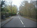
2
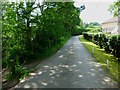
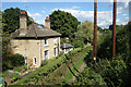
Navigating northwards up the Basher (16)
Houses in Compass Rose Road
Image: © Basher Eyre
Taken: 11 Apr 2023
0.06 miles
3
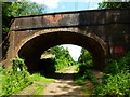
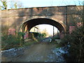
Bridge carrying White Lane over disused railway
The former station house is seen through the bridge. See http://www.disused-stations.org.uk/a/ash_green/ for more information.
An earlier view is at http://www.geograph.org.uk/photo/1873383.
Image: © Shazz
Taken: 21 Jun 2014
0.06 miles
4
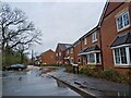
Compass Rose Road, Ash Green
A new housing development with a rather unusual street name.
Image: © Des Blenkinsopp
Taken: 16 Sep 2022
0.06 miles
5
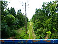
'Christmas Pie Trail' ex-Tongham railway trackbed, Ash Green
View towards what was Ash Junction, Ash Green station (suffix alternating between 'Green' 'Halt' and simply Ash through the years) once lay on the Farnham Junction-Ash Junction route via Tongham. The line was never electrified.
The existing Ash station, of course, still remains on the North Downs Line.
Image: © Sam
Taken: 22 Jan 2017
0.06 miles
6
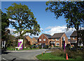
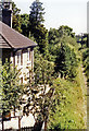
Site of Ash Green Station
Beside an old railway route now used as a cycleway and path.
For more information see Ben Brooksbank's extensively researched picture Image
Image: © Des Blenkinsopp
Taken: 16 Sep 2022
0.07 miles
7
Dismantled railway line looking west
The bridge in the distance carries White Lane.
Image: © Shazz
Taken: 21 Jun 2014
0.07 miles
8
Site of Ash Green station, 1990
View eastward, towards Ash Junction and Guildford. The station, closed from 4/7/37, was where the house is situated. This was the former 'Tongham Loop', a relic of the original (1849) LSWR Farnham branch from Guildford, which was superseded in 1865 by the direct line from Pirbight Junction through Aldershot to Farnham. After 1937 the single-line 'Tongham Loop' proved useful in the War for hiding ammunition trains in the woods - but one was bombed and set on fire in August 1940, and remained open for goods until 1/55 (1/61 as far as Tongham). (See also Image] and Image]).
Image: © Ben Brooksbank
Taken: 14 Jul 1990
0.08 miles
9
White Lane looking towards the railway bridge
Image: © David Howard
Taken: 18 Mar 2012
0.08 miles
10
"The Old Railway Path" notice
This is by the erstwhile Ash Green Halt.
Image: © Shazz
Taken: 21 Jun 2014
0.08 miles