IMAGES TAKEN NEAR TO
Youngs Drive, ALDERSHOT, GU12 6RE
Introduction
This page details the photographs taken nearby to Youngs Drive, GU12 6RE by members of the Geograph project.
The Geograph project started in 2005 with the aim of publishing, organising and preserving representative images for every square kilometre of Great Britain, Ireland and the Isle of Man.

There are currently over 7.5m images from over14,400 individuals and you can help contribute to the project by visiting https://www.geograph.org.uk
Image Map (Loading...)


Getting Data...Please wait
Leaflet Map data © OpenStreetMap
Images are licensed for reuse under creativecommons.org/licenses/by-sa/2.0
Notes
- Clicking on the map will re-center to the selected point.
- The higher the marker number, the further away the image location is from the centre of the postcode.
Image Listing (9 Images Found)
Images are licensed for reuse under creativecommons.org/licenses/by-sa/2.0
Image
Details
Distance
3
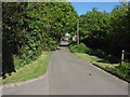
Shawfield Lane, Ash
Looking east along Shawfield Lane towards the junction with Shawfield Road.
Image: © Alan Hunt
Taken: 27 May 2013
0.17 miles
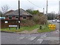
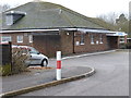
6
Rowan Field
Rowan Field recreation area off Shawfield Lane.
Image: © Alan Hunt
Taken: 27 May 2013
0.22 miles
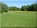
7
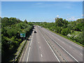
The Blackwater Valley Relief Road
The view north along the A331 from the bridge that carries the path from Shawfield Lane across the Blackwater Valley.
Image: © Alan Hunt
Taken: 27 May 2013
0.23 miles