IMAGES TAKEN NEAR TO
Wandle Close, ALDERSHOT, GU12 6JT
Introduction
This page details the photographs taken nearby to Wandle Close, GU12 6JT by members of the Geograph project.
The Geograph project started in 2005 with the aim of publishing, organising and preserving representative images for every square kilometre of Great Britain, Ireland and the Isle of Man.

There are currently over 7.5m images from over14,400 individuals and you can help contribute to the project by visiting https://www.geograph.org.uk
Image Map (Loading...)


Getting Data...Please wait
Leaflet Map data © OpenStreetMap
Images are licensed for reuse under creativecommons.org/licenses/by-sa/2.0
Notes
- Clicking on the map will re-center to the selected point.
- The higher the marker number, the further away the image location is from the centre of the postcode.
Image Listing (21 Images Found)
Images are licensed for reuse under creativecommons.org/licenses/by-sa/2.0
Image
Details
Distance
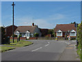
2
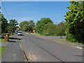
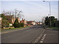
South Lane, Ash
Looking north along South Lane with the junction of The Briars on the right.
Image: © Alan Hunt
Taken: 27 May 2013
0.10 miles
3
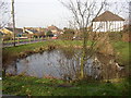
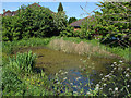
Pond, South Lane, Ash, Surrey
Landscaped ponds seem to be a feature of many modern residential developments in Surrey. This view is looking northwards, with South Lane behind the pond.
Image: © Humphrey Bolton
Taken: 24 Jan 2006
0.10 miles
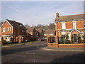
4
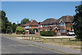
Set back from South Lane
Town houses like ones you see all over the place, but just setting them back that short distance off the road makes them look a bit special.
Image: © Des Blenkinsopp
Taken: 10 Aug 2022
0.12 miles
5
Pond, South Lane
The small pond on the corner between South Lane and Parish Close. This appears to be a recent addition as there is no record of this pond on the pre-1970s maps.
Image: © Alan Hunt
Taken: 27 May 2013
0.12 miles
6
Ash Street, Ash, Surrey
Looking eastwards. Here is a rare quiet period on this busy main road (A323). In the 19C, there were houses here and there along the road, some of them dating from the 16C and 17C. Now all the gaps are filled and it is solid suburbia.
Image: © Humphrey Bolton
Taken: 24 Jan 2006
0.14 miles
7
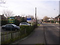
Estate agent's signs, Ash Street, Ash, Surrey
There is a block of flats to the left, and a long row of estate agent's signs along the roadside. This is looking westwards from near to the Grange Road junction.
Image: © Humphrey Bolton
Taken: 24 Jan 2006
0.14 miles
8
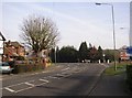
Road junction, Ash Street / Grange Road, Ash, Surrey
It is the pollarded tree (elm?) that makes this scene. The road curving to the left is Ash Church Road.
Image: © Humphrey Bolton
Taken: 24 Jan 2006
0.15 miles
9
South Lane, Ash
The junction of South Lane with Grange Road on the right.
Image: © Alan Hunt
Taken: 27 May 2013
0.16 miles
10
Queen Elizabeth Close, Ash Street, Ash, Surrey
The house on the right looks to be genuinely old, judging by its tall casement windows with arched lintels, but the new houses match it well, using the same colour of brick in the walls and in the quoins at the corners.
Image: © Humphrey Bolton
Taken: 24 Jan 2006
0.16 miles