IMAGES TAKEN NEAR TO
Foreman Park, ALDERSHOT, GU12 6JN
Introduction
This page details the photographs taken nearby to Foreman Park, GU12 6JN by members of the Geograph project.
The Geograph project started in 2005 with the aim of publishing, organising and preserving representative images for every square kilometre of Great Britain, Ireland and the Isle of Man.

There are currently over 7.5m images from over14,400 individuals and you can help contribute to the project by visiting https://www.geograph.org.uk
Image Map (Loading...)


Getting Data...Please wait
Leaflet Map data © OpenStreetMap
Images are licensed for reuse under creativecommons.org/licenses/by-sa/2.0
Notes
- Clicking on the map will re-center to the selected point.
- The higher the marker number, the further away the image location is from the centre of the postcode.
Image Listing (74 Images Found)
Images are licensed for reuse under creativecommons.org/licenses/by-sa/2.0
Image
Details
Distance
1
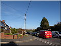
2016: a year on Geograph (Day 74)
Junction of Britten Close and Ash Church Road
Image: © Basher Eyre
Taken: 14 Mar 2016
0.05 miles
5
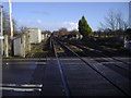
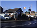
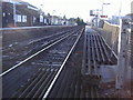
Railway line by Ash station
Taken from the level crossing with the station to the rear.
Image: © David Howard
Taken: 8 Mar 2009
0.09 miles
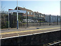
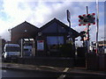
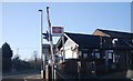
7
Kendall Self Drive at Ash Station
Like at many stations, there is no surviving old railway architecture left at today's minimalist platform and bus shelter structure.
But what looks like an old engine shed has been preserved by being sold off into business use, in this case a car and van hire company.
Image: © Des Blenkinsopp
Taken: 10 Aug 2022
0.09 miles
10
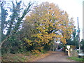
Church Lane, Ash
Leafy lane leading to St Peter's, Ash's Norman church.
http://www.british-history.ac.uk/report.aspx?compid=42979
Image: © Colin Smith
Taken: 30 Nov 2011
0.10 miles