IMAGES TAKEN NEAR TO
Horseshoe Lane, ALDERSHOT, GU12 5LL
Introduction
This page details the photographs taken nearby to Horseshoe Lane, GU12 5LL by members of the Geograph project.
The Geograph project started in 2005 with the aim of publishing, organising and preserving representative images for every square kilometre of Great Britain, Ireland and the Isle of Man.

There are currently over 7.5m images from over14,400 individuals and you can help contribute to the project by visiting https://www.geograph.org.uk
Image Map (Loading...)


Getting Data...Please wait
Leaflet Map data © OpenStreetMap
Images are licensed for reuse under creativecommons.org/licenses/by-sa/2.0
Notes
- Clicking on the map will re-center to the selected point.
- The higher the marker number, the further away the image location is from the centre of the postcode.
Image Listing (86 Images Found)
Images are licensed for reuse under creativecommons.org/licenses/by-sa/2.0
Image
Details
Distance
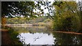
4
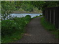
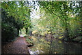
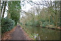
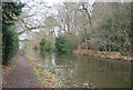
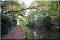
Canal tow path
The Basingstoke Canal tow path with Great Bottom Flash in the background.
Image: © Alan Hunt
Taken: 25 May 2013
0.09 miles
6
Red flag flying
Indicating that the ranges are closed, due to live firing.
Image: © N Chadwick
Taken: 13 Apr 2013
0.09 miles
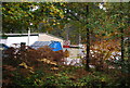
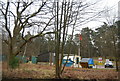
8
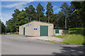
Workshop, Ash Ranges
A workshop near the ETR range in Ash Ranges.
Image: © Alan Hunt
Taken: 11 Jul 2015
0.11 miles