IMAGES TAKEN NEAR TO
Wharf Road, ALDERSHOT, GU12 5AY
Introduction
This page details the photographs taken nearby to Wharf Road, GU12 5AY by members of the Geograph project.
The Geograph project started in 2005 with the aim of publishing, organising and preserving representative images for every square kilometre of Great Britain, Ireland and the Isle of Man.

There are currently over 7.5m images from over14,400 individuals and you can help contribute to the project by visiting https://www.geograph.org.uk
Image Map
Images are licensed for reuse under creativecommons.org/licenses/by-sa/2.0
Notes
- Clicking on the map will re-center to the selected point.
- The higher the marker number, the further away the image location is from the centre of the postcode.
Image Listing (72 Images Found)
Images are licensed for reuse under creativecommons.org/licenses/by-sa/2.0
Image
Details
Distance
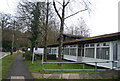
1
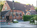
Ash Vale Methodist church
No longer used as a church
Image: © mike mullard
Taken: 18 Jun 2007
0.03 miles
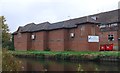
8
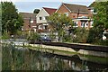
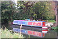
Houses backing on to the Basingstoke Canal
Note the very low water level in the pound - at least 0.5m below the proper level.
Image: © David Martin
Taken: 3 Oct 2022
0.07 miles