IMAGES TAKEN NEAR TO
St. Augustines Close, ALDERSHOT, GU12 4SF
Introduction
This page details the photographs taken nearby to St. Augustines Close, GU12 4SF by members of the Geograph project.
The Geograph project started in 2005 with the aim of publishing, organising and preserving representative images for every square kilometre of Great Britain, Ireland and the Isle of Man.

There are currently over 7.5m images from over14,400 individuals and you can help contribute to the project by visiting https://www.geograph.org.uk
Image Map (Loading...)


Getting Data...Please wait
Leaflet Map data © OpenStreetMap
Images are licensed for reuse under creativecommons.org/licenses/by-sa/2.0
Notes
- Clicking on the map will re-center to the selected point.
- The higher the marker number, the further away the image location is from the centre of the postcode.
Image Listing (6 Images Found)
Images are licensed for reuse under creativecommons.org/licenses/by-sa/2.0
Image
Details
Distance
1
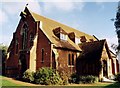
St Augustine, Aldershot
Built in 1907 as a mission church.
Image: © Michael FORD
Taken: Unknown
0.08 miles
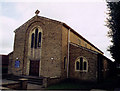
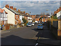
3
Belle vue Road, Aldershot
One of the residential roads in the North Town area of Aldershot.
Image: © Alan Hunt
Taken: 4 Mar 2015
0.14 miles
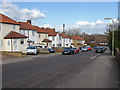
4
Belle Vue Road junction
The junction between Belle Vue Road with Holly Road in the North Town area of Aldershot.
Image: © Alan Hunt
Taken: 4 Mar 2015
0.20 miles
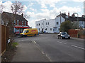
5
Canning Road, Aldershot
A residential cul-de-sac off North Lane.
Image: © Alan Hunt
Taken: 4 Mar 2015
0.22 miles
6
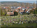
Aldershot North Town
Looking across the North Town area of Aldershot from the Redan Road cemetery. The ridge in the distance is the high ground of the Ash Ranges.
Image: © Alan Hunt
Taken: 4 Mar 2015
0.24 miles