IMAGES TAKEN NEAR TO
Chrismas Place, ALDERSHOT, GU12 4PL
Introduction
This page details the photographs taken nearby to Chrismas Place, GU12 4PL by members of the Geograph project.
The Geograph project started in 2005 with the aim of publishing, organising and preserving representative images for every square kilometre of Great Britain, Ireland and the Isle of Man.

There are currently over 7.5m images from over14,400 individuals and you can help contribute to the project by visiting https://www.geograph.org.uk
Image Map
Images are licensed for reuse under creativecommons.org/licenses/by-sa/2.0
Notes
- Clicking on the map will re-center to the selected point.
- The higher the marker number, the further away the image location is from the centre of the postcode.
Image Listing (40 Images Found)
Images are licensed for reuse under creativecommons.org/licenses/by-sa/2.0
Image
Details
Distance
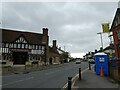
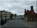
2
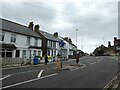
2016: a year on Geograph (Day 15)
The A323 at Aldershot: looking from the Shell Garage towards The Red Lion
Image: © Basher Eyre
Taken: 15 Jan 2016
0.09 miles
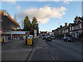
3
Looking from Church Hill through to the High Street
Image: © Basher Eyre
Taken: 10 Nov 2022
0.10 miles
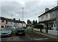
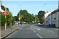
4
Looking from Brighton Road into Commercial Road
Image: © Basher Eyre
Taken: 10 Nov 2022
0.10 miles
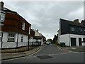
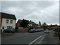
6
A323 High Street, Aldershot
Aldershot Manor Park is ahead.
Image: © Robin Webster
Taken: 11 Aug 2019
0.11 miles
7
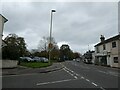
Junction of Elston Road with the High Street
Image: © Basher Eyre
Taken: 10 Nov 2022
0.11 miles
8
Looking from the High Street into Elston Road
Image: © Basher Eyre
Taken: 10 Nov 2022
0.11 miles
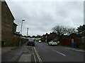
9
Looking northwards along Brighton Road towards the High Street
Image: © Basher Eyre
Taken: 10 Nov 2022
0.12 miles
10
Looking south-east along Brighton Road
Image: © Basher Eyre
Taken: 10 Nov 2022
0.13 miles