IMAGES TAKEN NEAR TO
St. Georges Road, ALDERSHOT, GU12 4JL
Introduction
This page details the photographs taken nearby to St. Georges Road, GU12 4JL by members of the Geograph project.
The Geograph project started in 2005 with the aim of publishing, organising and preserving representative images for every square kilometre of Great Britain, Ireland and the Isle of Man.

There are currently over 7.5m images from over14,400 individuals and you can help contribute to the project by visiting https://www.geograph.org.uk
Image Map (Loading...)


Getting Data...Please wait
Leaflet Map data © OpenStreetMap
Images are licensed for reuse under creativecommons.org/licenses/by-sa/2.0
Notes
- Clicking on the map will re-center to the selected point.
- The higher the marker number, the further away the image location is from the centre of the postcode.
Image Listing (256 Images Found)
Images are licensed for reuse under creativecommons.org/licenses/by-sa/2.0
Image
Details
Distance
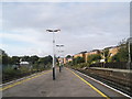
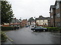
1
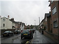
Looking southwestwards down St George's Road
Image: © Basher Eyre
Taken: 4 Oct 2008
0.01 miles
2
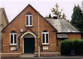
Former Episcopal Church, Aldershot
Built in 1901 as Christ Church. Latterly became Harland Hall and used as a Scouting Headquarters.
Image: © Michael FORD
Taken: Unknown
0.05 miles
4
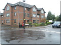
Flats on the corner of St George's Road and Station Road East
Image: © Basher Eyre
Taken: 4 Oct 2008
0.05 miles
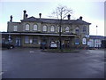
5
View south westwards from Aldershot Railway Station
Image: © Basher Eyre
Taken: 4 Oct 2008
0.06 miles
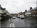
6
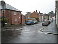
Junction of St George's Road and Station Road East
Image: © Basher Eyre
Taken: 4 Oct 2008
0.06 miles
7
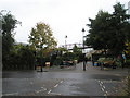
Rear entrance to Aldershot Railway Station
Image: © Basher Eyre
Taken: 4 Oct 2008
0.06 miles
8
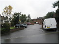
Private car park for the flats in Station Road East
Image: © Basher Eyre
Taken: 4 Oct 2008
0.06 miles
9
Looking from Station Road East down to George Road
Image: © Basher Eyre
Taken: 4 Oct 2008
0.06 miles
10
Junction of Station Road East and St George's Road
Image: © Basher Eyre
Taken: 4 Oct 2008
0.06 miles