IMAGES TAKEN NEAR TO
Institute Road, ALDERSHOT, GU12 4DA
Introduction
This page details the photographs taken nearby to Institute Road, GU12 4DA by members of the Geograph project.
The Geograph project started in 2005 with the aim of publishing, organising and preserving representative images for every square kilometre of Great Britain, Ireland and the Isle of Man.

There are currently over 7.5m images from over14,400 individuals and you can help contribute to the project by visiting https://www.geograph.org.uk
Image Map (Loading...)


Getting Data...Please wait
Leaflet Map data © OpenStreetMap
Images are licensed for reuse under creativecommons.org/licenses/by-sa/2.0
Notes
- Clicking on the map will re-center to the selected point.
- The higher the marker number, the further away the image location is from the centre of the postcode.
Image Listing (14 Images Found)
Images are licensed for reuse under creativecommons.org/licenses/by-sa/2.0
Image
Details
Distance
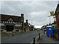
3
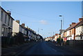
Houses and takeaway shops, Ash Road, Aldershot
Image: © Humphrey Bolton
Taken: 27 Jan 2001
0.13 miles
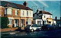
5
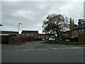
Looking from Brighton Road into Alfonso Close
Image: © Basher Eyre
Taken: 10 Nov 2022
0.20 miles
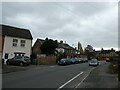
6
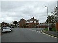
Looking back towards the junction of Alfonso Close and Brighton Road
Image: © Basher Eyre
Taken: 10 Nov 2022
0.20 miles
7
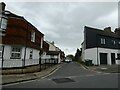
Looking from Brighton Road into Commercial Road
Image: © Basher Eyre
Taken: 10 Nov 2022
0.20 miles
10
Victorian Gasometer Being Dismantled
It's being taken down so this picture may not last long.
Image: © Brian Jacobs
Taken: 30 Aug 2004
0.22 miles