IMAGES TAKEN NEAR TO
Hollis Close, ALDERSHOT, GU11 4BY
Introduction
This page details the photographs taken nearby to Hollis Close, GU11 4BY by members of the Geograph project.
The Geograph project started in 2005 with the aim of publishing, organising and preserving representative images for every square kilometre of Great Britain, Ireland and the Isle of Man.

There are currently over 7.5m images from over14,400 individuals and you can help contribute to the project by visiting https://www.geograph.org.uk
Image Map (Loading...)


Getting Data...Please wait
Leaflet Map data © OpenStreetMap
Images are licensed for reuse under creativecommons.org/licenses/by-sa/2.0
Notes
- Clicking on the map will re-center to the selected point.
- The higher the marker number, the further away the image location is from the centre of the postcode.
Image Listing (46 Images Found)
Images are licensed for reuse under creativecommons.org/licenses/by-sa/2.0
Image
Details
Distance
1
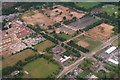
Aldershot Camp: some changes afoot (aerial 2016)
A comparison with the Satellite View shows that this area, marked the "Montgomery Lines" has mostly been flattened or redeveloped.
The Army Cricket Ground can be seen in the top right corner.
Image: © Chris
Taken: 13 Jun 2016
0.08 miles
2
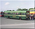
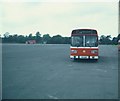
A Leyland National bus near Aldershot (1)
Taken in June 1981 between the A325 Farnborough Road and Queen's Avenue, exact location not known, this photo shows 49-seater Leyland National 231 (KPA 382P) dating from 1975. It is painted in the former livery of Aldershot & District bus company which was celebrating its 75th Anniversary, having begun services in May 1906.
Image: © David Hillas
Taken: 6 Jun 1981
0.13 miles
3
A Leyland National bus near Aldershot (2)
This photo shows a 1974 Leyland National bus 165 (TBL 165M) on the parade ground between the A325 Farnborough Road and Queens Avenue, exact position not known. It was one of 191 Leyland National buses that were delivered to Alder Valley between 1973 and 1978. All of these vehicles have long since been withdrawn. This particular was being driven by a member of the public at an Open Day that Alder Valley held at its Aldershot depot in June 1981.
Image: © David Hillas
Taken: 6 Jun 1981
0.13 miles
4
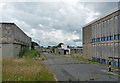
Derelict army buildings, Queen's Avenue, Aldershot
I think these are the former "Montgomery Lines, built for the Parachute Brigade in 1962-65. Four barrack clusters, mostly of textured concrete or with blue spandrels". Seemingly awaiting demolition.
Image: © Stephen Richards
Taken: 10 Jul 2012
0.14 miles
5
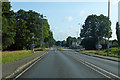
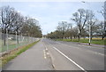
A325 Farnborough Road
Towards Farnborough, with an old military site being redeveloped on the right.
Image: © Robin Webster
Taken: 11 Aug 2019
0.15 miles
6
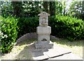
Memorial drinking fountain
The inscription reads "Near this spot on the 30th May 1910 Capt Charles Claudius de la Poer Beresford Royal Engineers was killed in a brave attempt to stop a runaway horse". (see http://www.geograph.org.uk/photo/4080699 for detail).
The fountain was thought to be erected about 1934 as it does nor appear on any O.S. maps before this date. See http://list.english-heritage.org.uk/resultsingle.aspx?uid=1393805 for more details.
Image: © Bikeboy
Taken: 13 Jul 2014
0.15 miles
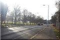
7
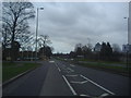
Turnoff for Fleet Road off Farnborough Road
The A323 meets the A30 at Hartley Wintney beyond Fleet
Image: © David Howard
Taken: 18 Mar 2012
0.15 miles
8
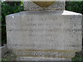
Detail of memorial drinking fountain
The inscription is very worn but it reads "Near this spot on the 30th May 1910 Capt Charles Claudius de la Poer Beresford Royal Engineers was killed in a brave attempt to stop a runaway horse". See http://www.geograph.org.uk/photo/4080695 for full view.
Image: © Bikeboy
Taken: 13 Jul 2014
0.15 miles