IMAGES TAKEN NEAR TO
Kiln Way, ALDERSHOT, GU11 3UG
Introduction
This page details the photographs taken nearby to Kiln Way, GU11 3UG by members of the Geograph project.
The Geograph project started in 2005 with the aim of publishing, organising and preserving representative images for every square kilometre of Great Britain, Ireland and the Isle of Man.

There are currently over 7.5m images from over14,400 individuals and you can help contribute to the project by visiting https://www.geograph.org.uk
Image Map (Loading...)


Getting Data...Please wait
Leaflet Map data © OpenStreetMap
Images are licensed for reuse under creativecommons.org/licenses/by-sa/2.0
Notes
- Clicking on the map will re-center to the selected point.
- The higher the marker number, the further away the image location is from the centre of the postcode.
Image Listing (55 Images Found)
Images are licensed for reuse under creativecommons.org/licenses/by-sa/2.0
Image
Details
Distance
2
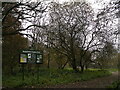
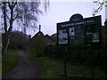
Information board within Brickfields Park
Image: © Basher Eyre
Taken: 8 Dec 2022
0.08 miles
4
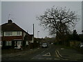
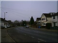
Looking from Boxall's Lane into Old Brickfield Road
Image: © Basher Eyre
Taken: 8 Dec 2022
0.10 miles
5
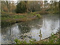
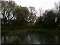
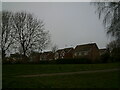
Looking across a pond towards houses in Jubilee Road
Image: © Basher Eyre
Taken: 8 Dec 2022
0.11 miles
7
Looking from Boxall's Lane into Oast Lane
Image: © Basher Eyre
Taken: 8 Dec 2022
0.11 miles
8
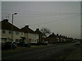
Houses in Laurel Gardens seen from Brickfields Park
Image: © Basher Eyre
Taken: 8 Dec 2022
0.12 miles
9
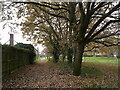
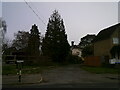
Entrance to Brickfields Park in Boxall's Lane
Image: © Basher Eyre
Taken: 8 Dec 2022
0.12 miles