IMAGES TAKEN NEAR TO
Church Lane West, ALDERSHOT, GU11 3LW
Introduction
This page details the photographs taken nearby to Church Lane West, GU11 3LW by members of the Geograph project.
The Geograph project started in 2005 with the aim of publishing, organising and preserving representative images for every square kilometre of Great Britain, Ireland and the Isle of Man.

There are currently over 7.5m images from over14,400 individuals and you can help contribute to the project by visiting https://www.geograph.org.uk
Image Map
Images are licensed for reuse under creativecommons.org/licenses/by-sa/2.0
Notes
- Clicking on the map will re-center to the selected point.
- The higher the marker number, the further away the image location is from the centre of the postcode.
Image Listing (11 Images Found)
Images are licensed for reuse under creativecommons.org/licenses/by-sa/2.0
Image
Details
Distance
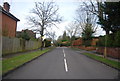
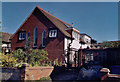
1
Church of The Ascension, Aldershot
Built in 1943.
Image: © Michael FORD
Taken: Unknown
0.07 miles
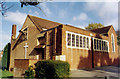
6
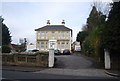
Former Church of St Aidan, Aldershot
Built for the Church of England but now converted into a private residence.
Image: © Michael FORD
Taken: Unknown
0.23 miles
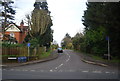
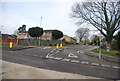
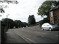
7
Junction of Church Lane West and Grosvenor Road
Image: © Basher Eyre
Taken: 4 Oct 2008
0.23 miles
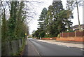
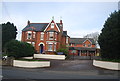
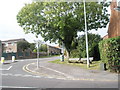
9
Approaching Church Lane West from Grosvenor Road
Image: © Basher Eyre
Taken: 4 Oct 2008
0.24 miles