IMAGES TAKEN NEAR TO
Cameron Road, ALDERSHOT, GU11 2NB
Introduction
This page details the photographs taken nearby to Cameron Road, GU11 2NB by members of the Geograph project.
The Geograph project started in 2005 with the aim of publishing, organising and preserving representative images for every square kilometre of Great Britain, Ireland and the Isle of Man.

There are currently over 7.5m images from over14,400 individuals and you can help contribute to the project by visiting https://www.geograph.org.uk
Image Map
Images are licensed for reuse under creativecommons.org/licenses/by-sa/2.0
Notes
- Clicking on the map will re-center to the selected point.
- The higher the marker number, the further away the image location is from the centre of the postcode.
Image Listing (15 Images Found)
Images are licensed for reuse under creativecommons.org/licenses/by-sa/2.0
Image
Details
Distance
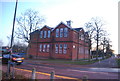
1
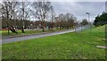
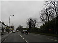
2016: a year on Geograph (Day 147)
Junction of North and Cadogan Roads.
If you go left you get to Redvers Buller Road; and if you go right you get to Cameron Road.
Image: © Basher Eyre
Taken: 26 May 2016
0.06 miles
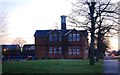
2
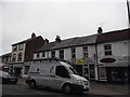
The Connaught Centre
Local area community centre.
Image: © James Emmans
Taken: 3 Jan 2022
0.17 miles
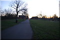
3
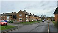
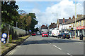
O'Connor Road in North Camp
Road towards Ramillies Park near junction of Rimbaud Close.
Image: © James Emmans
Taken: 3 Jan 2022
0.18 miles
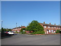
7
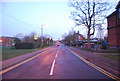
A3011 Lynchford Road, South Farnborough
Heading west, Lille Barracks is behind the fence on the left.
Image: © Robin Webster
Taken: 22 Aug 2020
0.23 miles