IMAGES TAKEN NEAR TO
Dukes Park, ALDERSHOT, GU11 2LW
Introduction
This page details the photographs taken nearby to Dukes Park, GU11 2LW by members of the Geograph project.
The Geograph project started in 2005 with the aim of publishing, organising and preserving representative images for every square kilometre of Great Britain, Ireland and the Isle of Man.

There are currently over 7.5m images from over14,400 individuals and you can help contribute to the project by visiting https://www.geograph.org.uk
Image Map
Images are licensed for reuse under creativecommons.org/licenses/by-sa/2.0
Notes
- Clicking on the map will re-center to the selected point.
- The higher the marker number, the further away the image location is from the centre of the postcode.
Image Listing (9 Images Found)
Images are licensed for reuse under creativecommons.org/licenses/by-sa/2.0
Image
Details
Distance
1
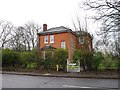
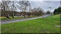
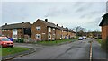
Dukes Park
A short residential road next to Dukes Park.
Image: © James Emmans
Taken: 3 Jan 2022
0.06 miles
2
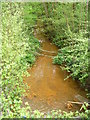
Polluted Stream by North Camp
Narrow stream emerging from underneath Alanbrooke Road in Aldershot. The water is a very unhealthy brown colour and the discarded shopping trolley does nothing to enhance the scene.
Image: © Colin Smith
Taken: 16 Apr 2011
0.10 miles
4
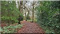
Ramillies Park
Woodlands near the sewage works.
Image: © James Emmans
Taken: 3 Jan 2022
0.12 miles
5
The Connaught Centre
Local area community centre.
Image: © James Emmans
Taken: 3 Jan 2022
0.14 miles
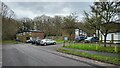
7
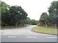
Camp Farm Road, Aldershot
Looking towards the barracks
Image: © David Howard
Taken: 5 Sep 2016
0.19 miles
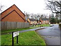
8
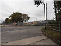
O'Connor Road in North Camp
Road towards Ramillies Park near junction of Rimbaud Close.
Image: © James Emmans
Taken: 3 Jan 2022
0.21 miles