IMAGES TAKEN NEAR TO
Chilloway Close, FARNHAM, GU10 5SB
Introduction
This page details the photographs taken nearby to Chilloway Close, GU10 5SB by members of the Geograph project.
The Geograph project started in 2005 with the aim of publishing, organising and preserving representative images for every square kilometre of Great Britain, Ireland and the Isle of Man.

There are currently over 7.5m images from over14,400 individuals and you can help contribute to the project by visiting https://www.geograph.org.uk
Image Map
Images are licensed for reuse under creativecommons.org/licenses/by-sa/2.0
Notes
- Clicking on the map will re-center to the selected point.
- The higher the marker number, the further away the image location is from the centre of the postcode.
Image Listing (6 Images Found)
Images are licensed for reuse under creativecommons.org/licenses/by-sa/2.0
Image
Details
Distance
1
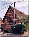
Former Methodist Chapel, Crondall
Erected in 1879 and closed in 1979. Now a private residence.
Image: © Michael FORD
Taken: Unknown
0.10 miles
2

Golf Course, Crondall
Looking eastwards along the footpath at the edge of the golf course.
Image: © Colin Smith
Taken: 31 Mar 2007
0.12 miles
3
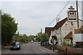
The Hampshire Arms
Greene King pub on Pankridge Street.
Image: © Oast House Archive
Taken: 19 May 2013
0.16 miles
4
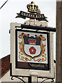
The Hampshire Arms sign
Sign for Image a Greene King pub on Pankridge Street.
Image: © Oast House Archive
Taken: 19 May 2013
0.16 miles
5

Green Springs, Crondall
Part of a small estate on the north-western edge of the village.
Image: © Andrew Smith
Taken: 2 Dec 2021
0.20 miles
6
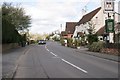
Crondall
The Hampshire Arms public house on the road from Crondall to Bowling Alley.
Image: © Brendan and Ruth McCartney
Taken: 18 Apr 2005
0.22 miles