IMAGES TAKEN NEAR TO
Farnham Road, FARNHAM, GU10 5RS
Introduction
This page details the photographs taken nearby to Farnham Road, GU10 5RS by members of the Geograph project.
The Geograph project started in 2005 with the aim of publishing, organising and preserving representative images for every square kilometre of Great Britain, Ireland and the Isle of Man.

There are currently over 7.5m images from over14,400 individuals and you can help contribute to the project by visiting https://www.geograph.org.uk
Image Map
Images are licensed for reuse under creativecommons.org/licenses/by-sa/2.0
Notes
- Clicking on the map will re-center to the selected point.
- The higher the marker number, the further away the image location is from the centre of the postcode.
Image Listing (5 Images Found)
Images are licensed for reuse under creativecommons.org/licenses/by-sa/2.0
Image
Details
Distance
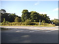
1

Looking west on the A287 at start of dual carriageway
On the far side of the road is a Nature Reserve.
Image: © Shazz
Taken: 22 Dec 2013
0.10 miles
3

Looking north from the A287
The road ahead goes to an electricity substation
Image: © Shazz
Taken: 22 Dec 2013
0.18 miles

5
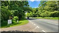
Great Rye Farm entrance on the A287
Busy main road called the Farnham Road with no made up path for walkers.
Image: © James Emmans
Taken: 3 Jun 2022
0.22 miles