IMAGES TAKEN NEAR TO
Crondall, FARNHAM, GU10 5PX
Introduction
This page details the photographs taken nearby to GU10 5PX by members of the Geograph project.
The Geograph project started in 2005 with the aim of publishing, organising and preserving representative images for every square kilometre of Great Britain, Ireland and the Isle of Man.

There are currently over 7.5m images from over14,400 individuals and you can help contribute to the project by visiting https://www.geograph.org.uk
Image Map
Images are licensed for reuse under creativecommons.org/licenses/by-sa/2.0
Notes
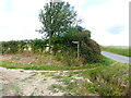
- Clicking on the map will re-center to the selected point.
- The higher the marker number, the further away the image location is from the centre of the postcode.
Image Listing (18 Images Found)
Images are licensed for reuse under creativecommons.org/licenses/by-sa/2.0
Image
Details
Distance
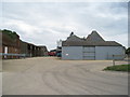
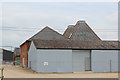
2
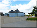
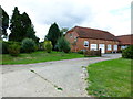
Barns at Penn Croft Farm
A photograph from the previous year is at http://www.geograph.org.uk/photo/3466923.
Image: © Shazz
Taken: 23 Aug 2014
0.01 miles
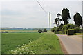
7
Line of poles crossing lane north of Penn Croft Farm
The lane may or may not be Hyde Lane.
Image: © Shazz
Taken: 23 Aug 2014
0.09 miles
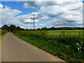
8
Road by Penn Croft Farm with view of pylon along field edge
Image: © Shazz
Taken: 23 Aug 2014
0.16 miles
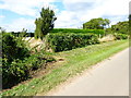
9
Footpath leaves lane south of Penn Croft Farm
Image: © Shazz
Taken: 23 Aug 2014
0.17 miles
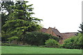
10
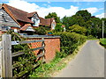
Itchel Cottage on Hyde Lane
The junction of Itchel Lane is immediately beyond the cottage.
Image: © Shazz
Taken: 23 Aug 2014
0.17 miles