IMAGES TAKEN NEAR TO
Bentley, FARNHAM, GU10 5LZ
Introduction
This page details the photographs taken nearby to GU10 5LZ by members of the Geograph project.
The Geograph project started in 2005 with the aim of publishing, organising and preserving representative images for every square kilometre of Great Britain, Ireland and the Isle of Man.

There are currently over 7.5m images from over14,400 individuals and you can help contribute to the project by visiting https://www.geograph.org.uk
Image Map
Images are licensed for reuse under creativecommons.org/licenses/by-sa/2.0
Notes
- Clicking on the map will re-center to the selected point.
- The higher the marker number, the further away the image location is from the centre of the postcode.
Image Listing (17 Images Found)
Images are licensed for reuse under creativecommons.org/licenses/by-sa/2.0
Image
Details
Distance
1
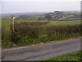
Footpath south to Bury Court
The white tops of the oast houses at Bury Court are clearly visible.
Image: © Shazz
Taken: 17 Mar 2011
0.06 miles
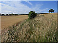
2
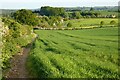
Farmland, Bentley
A footpath follows the edge of a field of spring barley as it descends to Bury Court.
Image: © Andrew Smith
Taken: 31 May 2021
0.08 miles
3
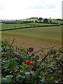
Fields by Bury Court Cottages
Taken from the public footpath running north north-west from Bury Court.
Image: © Hugh Chevallier
Taken: 3 Oct 2006
0.11 miles
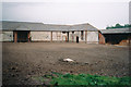
4
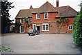
Bury Court Farm, Bentley Hampshire
I think this was the main farmhouse, amongst a large complex of farm buildings.
Image: © Elaine Champion
Taken: Unknown
0.11 miles
6
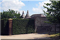
Oast House at Bury Court, Bentley, Hampshire
Image: © Oast House Archive
Taken: 24 Jun 2009
0.13 miles
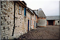
7
Farmyard at Bury Court, Bentley
Until the 1980s Bury Court was a hop farm, becoming a plant nursery, Green Farm Plants in the mid 1990s. When this photo was taken (probably May 1995) work appeared to have just commenced on turning the large farmyard into a contemporary walled garden, designed by Piet Oudolf.
The threshing barn seen here was moved to the site in the 1930s. In 2002 it was converted into a venue for weddings, corporate events and the like, also hosting opera and musical events. The nursery's show garden was incorporated into the hospitality business. As of April 2013 it is occasionally open to the public.
Image: © Elaine Champion
Taken: Unknown
0.13 miles
8
Oast House in the farmyard at Bury Court, Bentley
Until the 1980s Bury Court was a hop farm, becoming a plant nursery, Green Farm Plants in the mid 1990s. When this photo was taken (probably May 1995) work appeared to have just commenced on turning the large farmyard into a contemporary walled garden, designed by Piet Oudolf.
The threshing barn (building top right) was moved to the site in the 1930s. In 2002 it was converted into a venue for weddings, corporate events and the like, also hosting opera and musical events. The nursery's show garden was incorporated into the hospitality business. As of April 2013 it is occasionally open to the public. http://www.burycourtbarn.com/
Image: © Elaine Champion
Taken: Unknown
0.13 miles
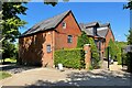
9
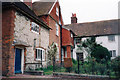
Cottages, at Bury Court, Bentley - May 1995
The main farmyard at Bury Court, a former hop farm, is located at the rear of these buildings.
Image: © Phil Champion
Taken: Unknown
0.15 miles
10
Farmland, Bentley
A footpath follows this field margin between fields of oats on the hillside to the north of Bury Court.
Image: © Andrew Smith
Taken: 10 Jul 2010
0.16 miles