IMAGES TAKEN NEAR TO
Bentley, FARNHAM, GU10 5LX
Introduction
This page details the photographs taken nearby to GU10 5LX by members of the Geograph project.
The Geograph project started in 2005 with the aim of publishing, organising and preserving representative images for every square kilometre of Great Britain, Ireland and the Isle of Man.

There are currently over 7.5m images from over14,400 individuals and you can help contribute to the project by visiting https://www.geograph.org.uk
Image Map
Images are licensed for reuse under creativecommons.org/licenses/by-sa/2.0
Notes
- Clicking on the map will re-center to the selected point.
- The higher the marker number, the further away the image location is from the centre of the postcode.
Image Listing (14 Images Found)
Images are licensed for reuse under creativecommons.org/licenses/by-sa/2.0
Image
Details
Distance
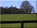
1
The Oast House, Isnage Farm, Bentley
Image: © Oast House Archive
Taken: 19 May 2013
0.00 miles
2
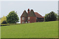
The Oast House, Isnage Farm, Bentley
Image: © Oast House Archive
Taken: 19 May 2013
0.00 miles
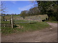
3
Isnage Farm, Well, Long Sutton
Old oast houses have been converted into living accommodation at Isnage Farm. There are a few hops still grown in the area, once famous for them.
Image: © Hugh Chevallier
Taken: 11 Jul 2006
0.03 miles
8
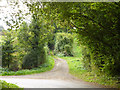
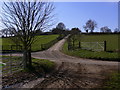
Husseys Lane
The start of the public byway.
Image: © Robin Webster
Taken: 25 Sep 2014
0.18 miles
9
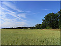
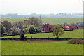
Farmland, Froyle
A crop of wheat to the west of Isnage Farm.
Image: © Andrew Smith
Taken: 10 Jul 2010
0.19 miles
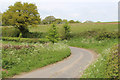
10
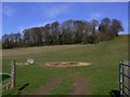
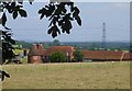
Pasture with manger and copse near Isnage Farm
Image: © Shazz
Taken: 19 Mar 2011
0.19 miles