IMAGES TAKEN NEAR TO
Rectory Lane, FARNHAM, GU10 5JR
Introduction
This page details the photographs taken nearby to Rectory Lane, GU10 5JR by members of the Geograph project.
The Geograph project started in 2005 with the aim of publishing, organising and preserving representative images for every square kilometre of Great Britain, Ireland and the Isle of Man.

There are currently over 7.5m images from over14,400 individuals and you can help contribute to the project by visiting https://www.geograph.org.uk
Image Map
Images are licensed for reuse under creativecommons.org/licenses/by-sa/2.0
Notes
- Clicking on the map will re-center to the selected point.
- The higher the marker number, the further away the image location is from the centre of the postcode.
Image Listing (31 Images Found)
Images are licensed for reuse under creativecommons.org/licenses/by-sa/2.0
Image
Details
Distance
1
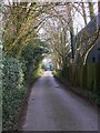
Rectory Lane in Bentley
This has public footpath status. The building on the right is in a small industrial estate.
Image: © Shazz
Taken: 17 Mar 2011
0.01 miles
3
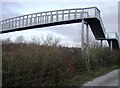
Footbridge over the A31
This footbridge retains the footpath link between the village of Bentley and its railway station, although most people probably drive.
Image: © Graham Horn
Taken: 25 Nov 2007
0.09 miles
4
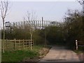
Footbridge over A31 at Bentley
This was taken from Rectory Lane. Another picture of the bridge is at http://www.geograph.org.uk/photo/630467.
Image: © Shazz
Taken: 17 Mar 2011
0.10 miles
5
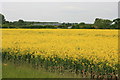
Yellow field near Bentley
Footbridge over the A31 viewed from Station Road across the yellow of oilseed rape.
Image: © Paul E Smith
Taken: 25 May 2009
0.10 miles
6
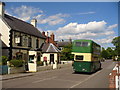
Bentley Village
This north-east Hampshire village once stood on the A-road from Alton to Farnham but now it is a sleepy place as it has been by-passed to the south.
The vintage double-decker passing the pub is an old Aldershot & District bus heading back to Farnham - it was the "Tracco" running day for old buses.
http://www.bentleyvillage.com/homepage.htm
Image: © Colin Smith
Taken: 30 May 2010
0.10 miles
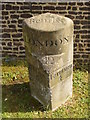
8
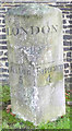
Old Milestone by the former A31, Bentley, Bentley parish
Hartford limestone diamond by the former A31, in parish of Bentley (East Hampshire District), near central crossroads, opposite marble obelisk commemorating Queen Victoria's Jubilee, on the verge.
Stolen since 2011 (? Visible on Streetview Aug 2020)
Inscription reads:-
: Alton / 5 : : LONDON / 42 : : Farnham / 4 :
Grade II listed.
List Entry Number: 1302214 https://historicengland.org.uk/listing/the-list/list-entry/1302214
Milestone Society National ID: HA_FAAL04
Image: © Milestone Society
Taken: Unknown
0.11 miles
9
Bentley Milestone
Old milestone on the south side of the main street through the village. On the reverse, shaded, side is an inscription with the miles to Winton - the archaic name for Winchester.
http://www.bentleyvillage.com/homepage.htm
Image: © Colin Smith
Taken: 30 May 2010
0.11 miles
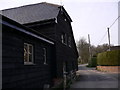
10
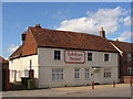
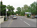
Red Lion House, Bentley
Presumably this fine old house used to be an inn. Today, Bentley has only one inn - The Star (left, off photograph).
http://www.bentleyvillage.com/homepage.htm
Image: © Colin Smith
Taken: 30 May 2010
0.11 miles