IMAGES TAKEN NEAR TO
Alton Road, FARNHAM, GU10 5EL
Introduction
This page details the photographs taken nearby to Alton Road, GU10 5EL by members of the Geograph project.
The Geograph project started in 2005 with the aim of publishing, organising and preserving representative images for every square kilometre of Great Britain, Ireland and the Isle of Man.

There are currently over 7.5m images from over14,400 individuals and you can help contribute to the project by visiting https://www.geograph.org.uk
Image Map
Images are licensed for reuse under creativecommons.org/licenses/by-sa/2.0
Notes
- Clicking on the map will re-center to the selected point.
- The higher the marker number, the further away the image location is from the centre of the postcode.
Image Listing (5 Images Found)
Images are licensed for reuse under creativecommons.org/licenses/by-sa/2.0
Image
Details
Distance
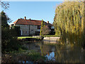
2
The River Wey
Downstream from Willey Mill.
Image: © Andrew Smith
Taken: 18 Nov 2006
0.14 miles
3
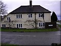
House at the bottom of Chamber Lane
The main road on the right is the A31.
Image: © Shazz
Taken: 26 Feb 2011
0.17 miles
4
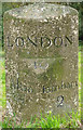
Old Milestone by the A31, Alton Road, west of Farnham
Carved stone post by the A31, in parish of Farnham (Waverley District), Alton Road, near junction with Camber Lane (Willey Place), on central reservation near island, in centre of road. Bagshot facet, erected by the Winchester, Upper District (Bagshot to Farnham) turnpike trust in the 19th century.
Inscription reads:-
: Alton / 7 : : FARNHAM / LONDON / 40 : : Farnham / 2 :
Grade II listed.
List Entry Number: 1044701 https://historicengland.org.uk/listing/the-list/list-entry/1044701
Milestone Society National ID: SY_LWW40
Image: © L Joseph
Taken: 1 Mar 2005
0.19 miles
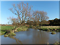
5
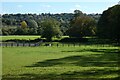
Pasture, Farnham
The paddocks of Willey Park Farm and a view across the Wey valley.
Image: © Andrew Smith
Taken: 9 Oct 2022
0.22 miles